You are here: Home > Network List > UW - Pacific Northwest Regional Seismic Network Stations List
> Station UMAT Pilot Rock, OR, USA > Earthquake Result Viewer
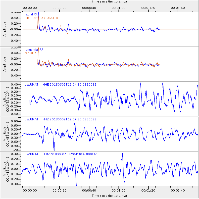
UMAT Pilot Rock, OR, USA - Earthquake Result Viewer
*The percent match for this event was below the threshold and hence no stack was calculated.
| Earthquake location: |
Samoa Islands Region |
| Earthquake latitude/longitude: |
-14.8/-173.1 |
| Earthquake time(UTC): |
2018/06/02 (153) 11:53:06 GMT |
| Earthquake Depth: |
50 km |
| Earthquake Magnitude: |
5.6 mb |
| Earthquake Catalog/Contributor: |
NEIC PDE/us |
|
| Network: |
UW Pacific Northwest Regional Seismic Network |
| Station: |
UMAT Pilot Rock, OR, USA |
| Lat/Lon: |
45.29 N/118.96 W |
| Elevation: |
1318 m |
|
| Distance: |
77.3 deg |
| Az: |
35.914 deg |
| Baz: |
233.496 deg |
| Ray Param: |
$rayparam |
*The percent match for this event was below the threshold and hence was not used in the summary stack. |
|
| Radial Match: |
79.34499 % |
| Radial Bump: |
253 |
| Transverse Match: |
67.8807 % |
| Transverse Bump: |
334 |
| SOD ConfigId: |
13570011 |
| Insert Time: |
2019-04-30 08:21:30.875 +0000 |
| GWidth: |
2.5 |
| Max Bumps: |
400 |
| Tol: |
0.001 |
|
Signal To Noise
| Channel | StoN | STA | LTA |
| UW:UMAT: :HHZ:20180602T12:04:30.638003Z | 0.4530073 | 3.2941973E-8 | 7.2718414E-8 |
| UW:UMAT: :HHN:20180602T12:04:30.638003Z | 1.0085837 | 5.8890375E-8 | 5.838918E-8 |
| UW:UMAT: :HHE:20180602T12:04:30.638003Z | 0.70244074 | 4.031298E-8 | 5.738986E-8 |
| Arrivals |
| Ps | |
| PpPs | |
| PsPs/PpSs | |


