You are here: Home > Network List > TA - USArray Transportable Network (new EarthScope stations) Stations List
> Station H18A Shoshone NF, Cody, WY, USA > Earthquake Result Viewer
H18A Shoshone NF, Cody, WY, USA - Earthquake Result Viewer

| Earthquake location: |
Southwestern Ryukyu Isl., Japan |
| Earthquake latitude/longitude: |
23.5/123.5 |
| Earthquake time(UTC): |
2009/08/17 (229) 00:05:49 GMT |
| Earthquake Depth: |
20 km |
| Earthquake Magnitude: |
6.2 MB, 6.6 MS, 6.7 MW, 6.6 MW |
| Earthquake Catalog/Contributor: |
WHDF/NEIC |
|
| Network: |
TA USArray Transportable Network (new EarthScope stations) |
| Station: |
H18A Shoshone NF, Cody, WY, USA |
| Lat/Lon: |
44.68 N/109.66 W |
| Elevation: |
2221 m |
|
| Distance: |
96.6 deg |
| Az: |
35.086 deg |
| Baz: |
312.3 deg |
| Ray Param: |
0.04046231 |
| Estimated Moho Depth: |
19.75 km |
| Estimated Crust Vp/Vs: |
1.60 |
| Assumed Crust Vp: |
6.242 km/s |
| Estimated Crust Vs: |
3.901 km/s |
| Estimated Crust Poisson's Ratio: |
0.18 |
|
| Radial Match: |
82.67488 % |
| Radial Bump: |
400 |
| Transverse Match: |
69.05513 % |
| Transverse Bump: |
400 |
| SOD ConfigId: |
2622 |
| Insert Time: |
2010-03-06 11:33:43.465 +0000 |
| GWidth: |
2.5 |
| Max Bumps: |
400 |
| Tol: |
0.001 |
|
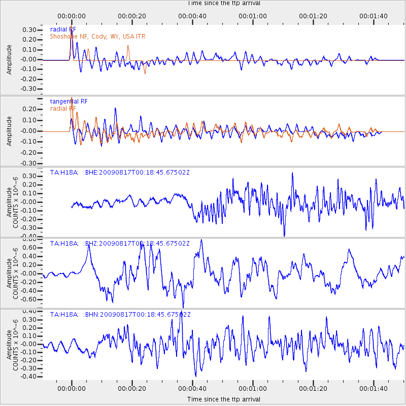
Signal To Noise
| Channel | StoN | STA | LTA |
| TA:H18A: :BHZ:20090817T00:18:45.67502Z | 2.853973 | 1.302487E-7 | 4.5637677E-8 |
| TA:H18A: :BHN:20090817T00:18:45.67502Z | 1.5451667 | 6.68284E-8 | 4.324996E-8 |
| TA:H18A: :BHE:20090817T00:18:45.67502Z | 1.5889329 | 5.7275024E-8 | 3.604622E-8 |
| Arrivals |
| Ps | 1.9 SECOND |
| PpPs | 8.1 SECOND |
| PsPs/PpSs | 10.0 SECOND |


