You are here: Home > Network List > TA - USArray Transportable Network (new EarthScope stations) Stations List
> Station H18A Shoshone NF, Cody, WY, USA > Earthquake Result Viewer
H18A Shoshone NF, Cody, WY, USA - Earthquake Result Viewer
| Earthquake location: |
Easter Island Region |
| Earthquake latitude/longitude: |
-29.1/-112.3 |
| Earthquake time(UTC): |
2009/09/17 (260) 23:21:38 GMT |
| Earthquake Depth: |
10 km |
| Earthquake Magnitude: |
5.7 MB, 6.0 MS, 6.2 MW, 6.2 MW |
| Earthquake Catalog/Contributor: |
WHDF/NEIC |
|
| Network: |
TA USArray Transportable Network (new EarthScope stations) |
| Station: |
H18A Shoshone NF, Cody, WY, USA |
| Lat/Lon: |
44.68 N/109.66 W |
| Elevation: |
2221 m |
|
| Distance: |
73.5 deg |
| Az: |
1.936 deg |
| Baz: |
182.375 deg |
| Ray Param: |
0.052960344 |
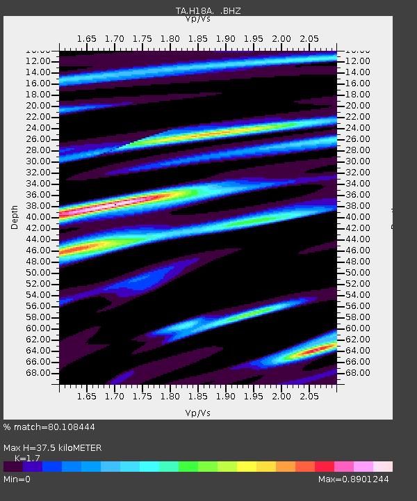
| Estimated Moho Depth: |
37.5 km |
| Estimated Crust Vp/Vs: |
1.70 |
| Assumed Crust Vp: |
6.242 km/s |
| Estimated Crust Vs: |
3.672 km/s |
| Estimated Crust Poisson's Ratio: |
0.24 |
|
| Radial Match: |
80.108444 % |
| Radial Bump: |
400 |
| Transverse Match: |
61.671463 % |
| Transverse Bump: |
400 |
| SOD ConfigId: |
2622 |
| Insert Time: |
2010-03-06 11:33:55.491 +0000 |
| GWidth: |
2.5 |
| Max Bumps: |
400 |
| Tol: |
0.001 |
|

Signal To Noise
| Channel | StoN | STA | LTA |
| TA:H18A: :BHZ:20090917T23:32:39.975017Z | 3.1628187 | 2.4050632E-7 | 7.6041765E-8 |
| TA:H18A: :BHN:20090917T23:32:39.975017Z | 1.1841221 | 1.0827172E-7 | 9.1436284E-8 |
| TA:H18A: :BHE:20090917T23:32:39.975017Z | 2.0900276 | 2.0004617E-7 | 9.571461E-8 |
| Arrivals |
| Ps | 4.3 SECOND |
| PpPs | 16 SECOND |
| PsPs/PpSs | 20 SECOND |


