You are here: Home > Network List > TA - USArray Transportable Network (new EarthScope stations) Stations List
> Station I23K Minto, Yukon-Koyukuk, AK, USA > Earthquake Result Viewer
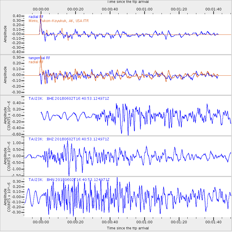
I23K Minto, Yukon-Koyukuk, AK, USA - Earthquake Result Viewer
*The percent match for this event was below the threshold and hence no stack was calculated.
| Earthquake location: |
Talaud Islands, Indonesia |
| Earthquake latitude/longitude: |
4.6/126.7 |
| Earthquake time(UTC): |
2018/06/02 (153) 16:29:01 GMT |
| Earthquake Depth: |
41 km |
| Earthquake Magnitude: |
5.7 Mww |
| Earthquake Catalog/Contributor: |
NEIC PDE/us |
|
| Network: |
TA USArray Transportable Network (new EarthScope stations) |
| Station: |
I23K Minto, Yukon-Koyukuk, AK, USA |
| Lat/Lon: |
65.15 N/149.36 W |
| Elevation: |
149 m |
|
| Distance: |
83.3 deg |
| Az: |
25.032 deg |
| Baz: |
266.439 deg |
| Ray Param: |
$rayparam |
*The percent match for this event was below the threshold and hence was not used in the summary stack. |
|
| Radial Match: |
77.4151 % |
| Radial Bump: |
400 |
| Transverse Match: |
64.76986 % |
| Transverse Bump: |
400 |
| SOD ConfigId: |
13570011 |
| Insert Time: |
2019-04-30 08:25:37.383 +0000 |
| GWidth: |
2.5 |
| Max Bumps: |
400 |
| Tol: |
0.001 |
|
Signal To Noise
| Channel | StoN | STA | LTA |
| TA:I23K: :BHZ:20180602T16:40:53.124971Z | 4.125451 | 2.672551E-7 | 6.4782036E-8 |
| TA:I23K: :BHN:20180602T16:40:53.124971Z | 1.1148372 | 1.03747404E-7 | 9.3060585E-8 |
| TA:I23K: :BHE:20180602T16:40:53.124971Z | 0.7815112 | 6.25692E-8 | 8.006181E-8 |
| Arrivals |
| Ps | |
| PpPs | |
| PsPs/PpSs | |


