You are here: Home > Network List > TA - USArray Transportable Network (new EarthScope stations) Stations List
> Station H18A Shoshone NF, Cody, WY, USA > Earthquake Result Viewer
H18A Shoshone NF, Cody, WY, USA - Earthquake Result Viewer
| Earthquake location: |
Fox Islands, Aleutian Islands |
| Earthquake latitude/longitude: |
52.6/-167.1 |
| Earthquake time(UTC): |
2009/10/13 (286) 20:21:53 GMT |
| Earthquake Depth: |
14 km |
| Earthquake Magnitude: |
5.9 MB, 6.4 MS, 6.4 MW, 6.4 MW |
| Earthquake Catalog/Contributor: |
WHDF/NEIC |
|
| Network: |
TA USArray Transportable Network (new EarthScope stations) |
| Station: |
H18A Shoshone NF, Cody, WY, USA |
| Lat/Lon: |
44.68 N/109.66 W |
| Elevation: |
2221 m |
|
| Distance: |
37.9 deg |
| Az: |
78.423 deg |
| Baz: |
303.126 deg |
| Ray Param: |
0.0758796 |
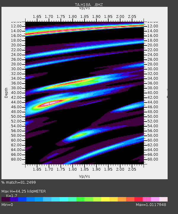
| Estimated Moho Depth: |
44.25 km |
| Estimated Crust Vp/Vs: |
1.70 |
| Assumed Crust Vp: |
6.242 km/s |
| Estimated Crust Vs: |
3.672 km/s |
| Estimated Crust Poisson's Ratio: |
0.24 |
|
| Radial Match: |
81.2499 % |
| Radial Bump: |
329 |
| Transverse Match: |
65.91377 % |
| Transverse Bump: |
400 |
| SOD ConfigId: |
2622 |
| Insert Time: |
2010-03-06 11:34:06.221 +0000 |
| GWidth: |
2.5 |
| Max Bumps: |
400 |
| Tol: |
0.001 |
|
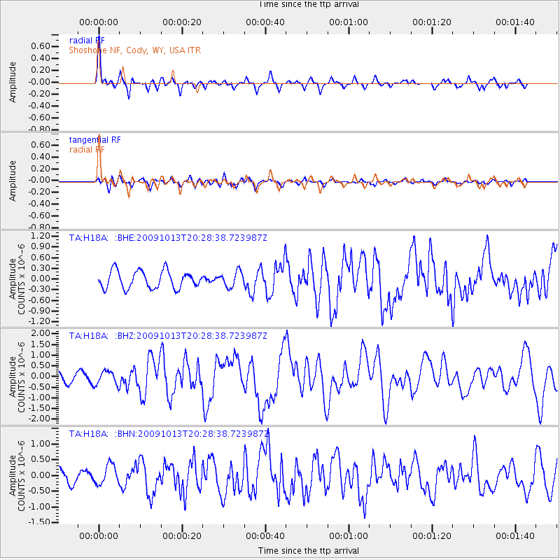
Signal To Noise
| Channel | StoN | STA | LTA |
| TA:H18A: :BHZ:20091013T20:28:38.723987Z | 1.3720864 | 3.1895925E-7 | 2.3246297E-7 |
| TA:H18A: :BHN:20091013T20:28:38.723987Z | 1.791115 | 3.200534E-7 | 1.7868946E-7 |
| TA:H18A: :BHE:20091013T20:28:38.723987Z | 0.90189844 | 2.1759682E-7 | 2.4126533E-7 |
| Arrivals |
| Ps | 5.3 SECOND |
| PpPs | 18 SECOND |
| PsPs/PpSs | 23 SECOND |


