You are here: Home > Network List > CI - Caltech Regional Seismic Network Stations List
> Station MPM Manuel Prospect Mine, California, USA > Earthquake Result Viewer
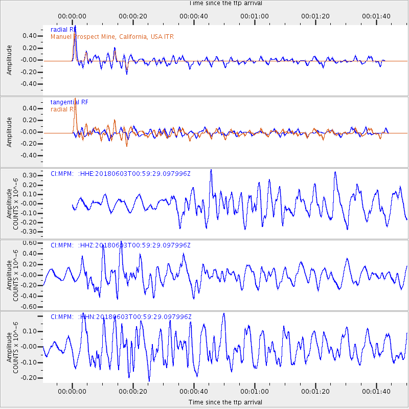
MPM Manuel Prospect Mine, California, USA - Earthquake Result Viewer
*The percent match for this event was below the threshold and hence no stack was calculated.
| Earthquake location: |
Tonga Islands |
| Earthquake latitude/longitude: |
-19.4/-173.7 |
| Earthquake time(UTC): |
2018/06/03 (154) 00:48:09 GMT |
| Earthquake Depth: |
10 km |
| Earthquake Magnitude: |
5.6 mb |
| Earthquake Catalog/Contributor: |
NEIC PDE/us |
|
| Network: |
CI Caltech Regional Seismic Network |
| Station: |
MPM Manuel Prospect Mine, California, USA |
| Lat/Lon: |
36.06 N/117.49 W |
| Elevation: |
185 m |
|
| Distance: |
76.6 deg |
| Az: |
43.803 deg |
| Baz: |
233.736 deg |
| Ray Param: |
$rayparam |
*The percent match for this event was below the threshold and hence was not used in the summary stack. |
|
| Radial Match: |
76.45452 % |
| Radial Bump: |
400 |
| Transverse Match: |
45.90683 % |
| Transverse Bump: |
400 |
| SOD ConfigId: |
13570011 |
| Insert Time: |
2019-04-30 08:30:11.339 +0000 |
| GWidth: |
2.5 |
| Max Bumps: |
400 |
| Tol: |
0.001 |
|
Signal To Noise
| Channel | StoN | STA | LTA |
| CI:MPM: :HHZ:20180603T00:59:29.097996Z | 1.4441526 | 1.3265185E-7 | 9.185446E-8 |
| CI:MPM: :HHN:20180603T00:59:29.097996Z | 1.5426646 | 1.1363092E-7 | 7.365886E-8 |
| CI:MPM: :HHE:20180603T00:59:29.097996Z | 0.8661479 | 4.396254E-8 | 5.0756395E-8 |
| Arrivals |
| Ps | |
| PpPs | |
| PsPs/PpSs | |


