You are here: Home > Network List > TA - USArray Transportable Network (new EarthScope stations) Stations List
> Station H18A Shoshone NF, Cody, WY, USA > Earthquake Result Viewer
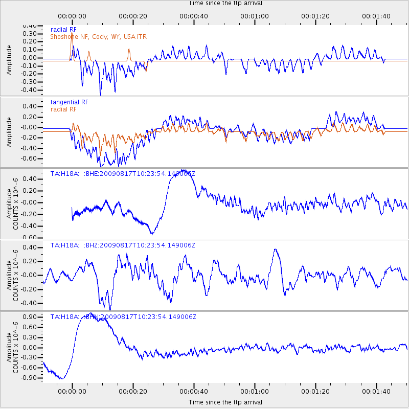
H18A Shoshone NF, Cody, WY, USA - Earthquake Result Viewer
*The percent match for this event was below the threshold and hence no stack was calculated.
| Earthquake location: |
Southwestern Ryukyu Isl., Japan |
| Earthquake latitude/longitude: |
23.4/123.5 |
| Earthquake time(UTC): |
2009/08/17 (229) 10:10:55 GMT |
| Earthquake Depth: |
10 km |
| Earthquake Magnitude: |
5.9 MB, 6.2 MS, 6.1 MW, 6.1 MW |
| Earthquake Catalog/Contributor: |
WHDF/NEIC |
|
| Network: |
TA USArray Transportable Network (new EarthScope stations) |
| Station: |
H18A Shoshone NF, Cody, WY, USA |
| Lat/Lon: |
44.68 N/109.66 W |
| Elevation: |
2221 m |
|
| Distance: |
96.6 deg |
| Az: |
35.105 deg |
| Baz: |
312.234 deg |
| Ray Param: |
$rayparam |
*The percent match for this event was below the threshold and hence was not used in the summary stack. |
|
| Radial Match: |
32.02296 % |
| Radial Bump: |
400 |
| Transverse Match: |
14.127856 % |
| Transverse Bump: |
400 |
| SOD ConfigId: |
2622 |
| Insert Time: |
2010-03-06 11:35:04.933 +0000 |
| GWidth: |
2.5 |
| Max Bumps: |
400 |
| Tol: |
0.001 |
|
Signal To Noise
| Channel | StoN | STA | LTA |
| TA:H18A: :BHZ:20090817T10:23:54.149006Z | 2.0682259 | 1.05170116E-7 | 5.0850403E-8 |
| TA:H18A: :BHN:20090817T10:23:54.149006Z | 4.6679792 | 8.9501816E-7 | 1.9173567E-7 |
| TA:H18A: :BHE:20090817T10:23:54.149006Z | 4.4754486 | 4.5611367E-7 | 1.0191462E-7 |
| Arrivals |
| Ps | |
| PpPs | |
| PsPs/PpSs | |


