You are here: Home > Network List > TA - USArray Transportable Network (new EarthScope stations) Stations List
> Station H18A Shoshone NF, Cody, WY, USA > Earthquake Result Viewer
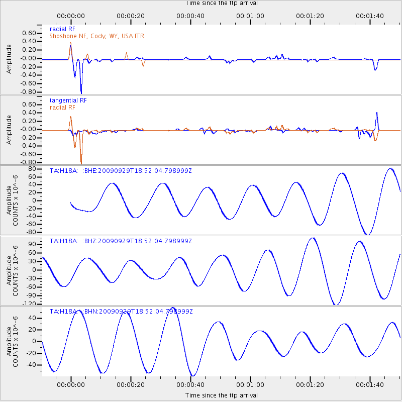
H18A Shoshone NF, Cody, WY, USA - Earthquake Result Viewer
*The percent match for this event was below the threshold and hence no stack was calculated.
| Earthquake location: |
Tonga Islands |
| Earthquake latitude/longitude: |
-15.4/-173.2 |
| Earthquake time(UTC): |
2009/09/29 (272) 18:40:09 GMT |
| Earthquake Depth: |
2.3 km |
| Earthquake Magnitude: |
5.5 MB |
| Earthquake Catalog/Contributor: |
WHDF/NEIC |
|
| Network: |
TA USArray Transportable Network (new EarthScope stations) |
| Station: |
H18A Shoshone NF, Cody, WY, USA |
| Lat/Lon: |
44.68 N/109.66 W |
| Elevation: |
2221 m |
|
| Distance: |
83.0 deg |
| Az: |
40.068 deg |
| Baz: |
240.509 deg |
| Ray Param: |
$rayparam |
*The percent match for this event was below the threshold and hence was not used in the summary stack. |
|
| Radial Match: |
93.66562 % |
| Radial Bump: |
322 |
| Transverse Match: |
44.856106 % |
| Transverse Bump: |
400 |
| SOD ConfigId: |
2622 |
| Insert Time: |
2010-03-06 11:35:17.328 +0000 |
| GWidth: |
2.5 |
| Max Bumps: |
400 |
| Tol: |
0.001 |
|
Signal To Noise
| Channel | StoN | STA | LTA |
| TA:H18A: :BHZ:20090929T18:52:04.798999Z | 0.9967356 | 3.095051E-5 | 3.1051874E-5 |
| TA:H18A: :BHN:20090929T18:52:04.798999Z | 1.8743626 | 4.5458924E-5 | 2.4253006E-5 |
| TA:H18A: :BHE:20090929T18:52:04.798999Z | 1.5051532 | 4.1410418E-5 | 2.7512428E-5 |
| Arrivals |
| Ps | |
| PpPs | |
| PsPs/PpSs | |


