You are here: Home > Network List > TA - USArray Transportable Network (new EarthScope stations) Stations List
> Station D23K Nanushuk River, AK USA > Earthquake Result Viewer
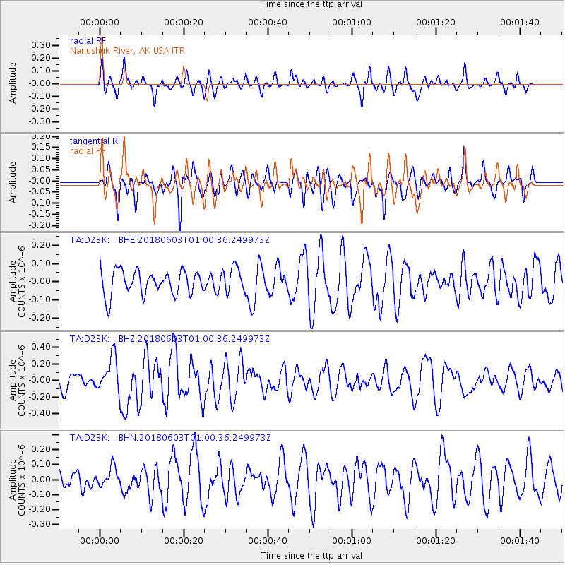
D23K Nanushuk River, AK USA - Earthquake Result Viewer
*The percent match for this event was below the threshold and hence no stack was calculated.
| Earthquake location: |
Tonga Islands |
| Earthquake latitude/longitude: |
-19.4/-173.7 |
| Earthquake time(UTC): |
2018/06/03 (154) 00:48:09 GMT |
| Earthquake Depth: |
10 km |
| Earthquake Magnitude: |
5.6 mb |
| Earthquake Catalog/Contributor: |
NEIC PDE/us |
|
| Network: |
TA USArray Transportable Network (new EarthScope stations) |
| Station: |
D23K Nanushuk River, AK USA |
| Lat/Lon: |
68.97 N/150.68 W |
| Elevation: |
406 m |
|
| Distance: |
89.7 deg |
| Az: |
8.11 deg |
| Baz: |
201.644 deg |
| Ray Param: |
$rayparam |
*The percent match for this event was below the threshold and hence was not used in the summary stack. |
|
| Radial Match: |
62.97646 % |
| Radial Bump: |
345 |
| Transverse Match: |
62.159325 % |
| Transverse Bump: |
394 |
| SOD ConfigId: |
13570011 |
| Insert Time: |
2019-04-30 08:34:07.116 +0000 |
| GWidth: |
2.5 |
| Max Bumps: |
400 |
| Tol: |
0.001 |
|
Signal To Noise
| Channel | StoN | STA | LTA |
| TA:D23K: :BHZ:20180603T01:00:36.249973Z | 1.6694783 | 2.1954256E-7 | 1.3150368E-7 |
| TA:D23K: :BHN:20180603T01:00:36.249973Z | 1.0457598 | 6.455613E-8 | 6.173132E-8 |
| TA:D23K: :BHE:20180603T01:00:36.249973Z | 1.0308157 | 6.830839E-8 | 6.6266345E-8 |
| Arrivals |
| Ps | |
| PpPs | |
| PsPs/PpSs | |


