You are here: Home > Network List > TA - USArray Transportable Network (new EarthScope stations) Stations List
> Station G31M Satah River, YT, CAN > Earthquake Result Viewer
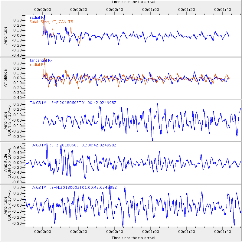
G31M Satah River, YT, CAN - Earthquake Result Viewer
*The percent match for this event was below the threshold and hence no stack was calculated.
| Earthquake location: |
Tonga Islands |
| Earthquake latitude/longitude: |
-19.4/-173.7 |
| Earthquake time(UTC): |
2018/06/03 (154) 00:48:09 GMT |
| Earthquake Depth: |
10 km |
| Earthquake Magnitude: |
5.6 mb |
| Earthquake Catalog/Contributor: |
NEIC PDE/us |
|
| Network: |
TA USArray Transportable Network (new EarthScope stations) |
| Station: |
G31M Satah River, YT, CAN |
| Lat/Lon: |
66.92 N/134.27 W |
| Elevation: |
61 m |
|
| Distance: |
90.9 deg |
| Az: |
14.496 deg |
| Baz: |
216.822 deg |
| Ray Param: |
$rayparam |
*The percent match for this event was below the threshold and hence was not used in the summary stack. |
|
| Radial Match: |
72.48098 % |
| Radial Bump: |
377 |
| Transverse Match: |
65.50073 % |
| Transverse Bump: |
400 |
| SOD ConfigId: |
13570011 |
| Insert Time: |
2019-04-30 08:34:44.216 +0000 |
| GWidth: |
2.5 |
| Max Bumps: |
400 |
| Tol: |
0.001 |
|
Signal To Noise
| Channel | StoN | STA | LTA |
| TA:G31M: :BHZ:20180603T01:00:42.024998Z | 3.80928 | 2.6220837E-7 | 6.8834105E-8 |
| TA:G31M: :BHN:20180603T01:00:42.024998Z | 1.5531001 | 7.450046E-8 | 4.796887E-8 |
| TA:G31M: :BHE:20180603T01:00:42.024998Z | 2.0385404 | 1.3492206E-7 | 6.618563E-8 |
| Arrivals |
| Ps | |
| PpPs | |
| PsPs/PpSs | |


