You are here: Home > Network List > TA - USArray Transportable Network (new EarthScope stations) Stations List
> Station J26L Joseph Creek, AK, USA > Earthquake Result Viewer
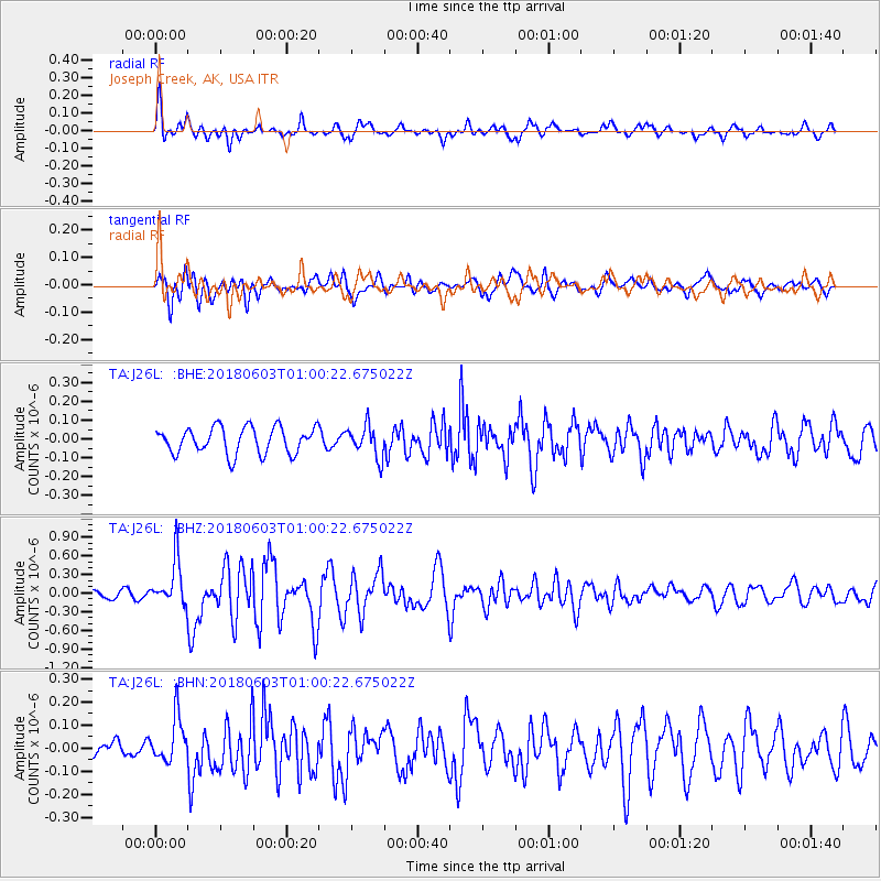
J26L Joseph Creek, AK, USA - Earthquake Result Viewer
*The percent match for this event was below the threshold and hence no stack was calculated.
| Earthquake location: |
Tonga Islands |
| Earthquake latitude/longitude: |
-19.4/-173.7 |
| Earthquake time(UTC): |
2018/06/03 (154) 00:48:09 GMT |
| Earthquake Depth: |
10 km |
| Earthquake Magnitude: |
5.6 mb |
| Earthquake Catalog/Contributor: |
NEIC PDE/us |
|
| Network: |
TA USArray Transportable Network (new EarthScope stations) |
| Station: |
J26L Joseph Creek, AK, USA |
| Lat/Lon: |
64.50 N/143.56 W |
| Elevation: |
1144 m |
|
| Distance: |
86.8 deg |
| Az: |
12.564 deg |
| Baz: |
208.318 deg |
| Ray Param: |
$rayparam |
*The percent match for this event was below the threshold and hence was not used in the summary stack. |
|
| Radial Match: |
79.25618 % |
| Radial Bump: |
362 |
| Transverse Match: |
67.759056 % |
| Transverse Bump: |
400 |
| SOD ConfigId: |
13570011 |
| Insert Time: |
2019-04-30 08:35:07.309 +0000 |
| GWidth: |
2.5 |
| Max Bumps: |
400 |
| Tol: |
0.001 |
|
Signal To Noise
| Channel | StoN | STA | LTA |
| TA:J26L: :BHZ:20180603T01:00:22.675022Z | 6.6586103 | 3.711942E-7 | 5.5746497E-8 |
| TA:J26L: :BHN:20180603T01:00:22.675022Z | 2.0890338 | 9.723614E-8 | 4.6545985E-8 |
| TA:J26L: :BHE:20180603T01:00:22.675022Z | 1.0267138 | 7.0980676E-8 | 6.913384E-8 |
| Arrivals |
| Ps | |
| PpPs | |
| PsPs/PpSs | |


