You are here: Home > Network List > TA - USArray Transportable Network (new EarthScope stations) Stations List
> Station M27K Edge Creek, AK, USA > Earthquake Result Viewer
M27K Edge Creek, AK, USA - Earthquake Result Viewer
| Earthquake location: |
Tonga Islands |
| Earthquake latitude/longitude: |
-19.4/-173.7 |
| Earthquake time(UTC): |
2018/06/03 (154) 00:48:09 GMT |
| Earthquake Depth: |
10 km |
| Earthquake Magnitude: |
5.6 mb |
| Earthquake Catalog/Contributor: |
NEIC PDE/us |
|
| Network: |
TA USArray Transportable Network (new EarthScope stations) |
| Station: |
M27K Edge Creek, AK, USA |
| Lat/Lon: |
62.36 N/141.88 W |
| Elevation: |
1536 m |
|
| Distance: |
85.3 deg |
| Az: |
14.278 deg |
| Baz: |
209.942 deg |
| Ray Param: |
0.04486572 |
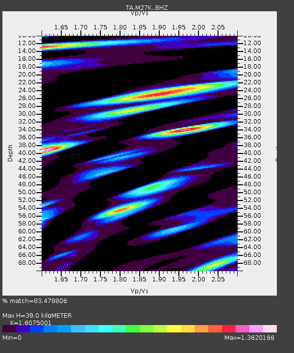
| Estimated Moho Depth: |
39.0 km |
| Estimated Crust Vp/Vs: |
1.61 |
| Assumed Crust Vp: |
6.566 km/s |
| Estimated Crust Vs: |
4.085 km/s |
| Estimated Crust Poisson's Ratio: |
0.18 |
|
| Radial Match: |
83.478806 % |
| Radial Bump: |
400 |
| Transverse Match: |
76.49868 % |
| Transverse Bump: |
400 |
| SOD ConfigId: |
13570011 |
| Insert Time: |
2019-04-30 08:35:30.956 +0000 |
| GWidth: |
2.5 |
| Max Bumps: |
400 |
| Tol: |
0.001 |
|

Signal To Noise
| Channel | StoN | STA | LTA |
| TA:M27K: :BHZ:20180603T01:00:15.274998Z | 6.394362 | 3.5135253E-7 | 5.4947236E-8 |
| TA:M27K: :BHN:20180603T01:00:15.274998Z | 2.3707967 | 1.7223937E-7 | 7.265042E-8 |
| TA:M27K: :BHE:20180603T01:00:15.274998Z | 1.445648 | 1.1404642E-7 | 7.8889485E-8 |
| Arrivals |
| Ps | 3.7 SECOND |
| PpPs | 15 SECOND |
| PsPs/PpSs | 19 SECOND |


