You are here: Home > Network List > TA - USArray Transportable Network (new EarthScope stations) Stations List
> Station H18A Shoshone NF, Cody, WY, USA > Earthquake Result Viewer
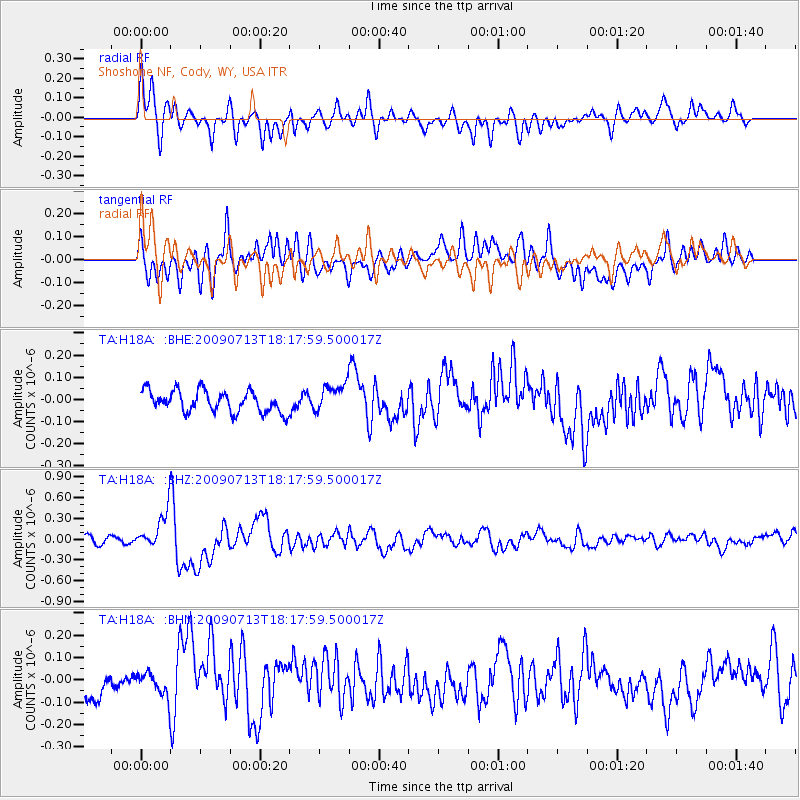
H18A Shoshone NF, Cody, WY, USA - Earthquake Result Viewer
*The percent match for this event was below the threshold and hence no stack was calculated.
| Earthquake location: |
Taiwan Region |
| Earthquake latitude/longitude: |
24.1/122.2 |
| Earthquake time(UTC): |
2009/07/13 (194) 18:05:01 GMT |
| Earthquake Depth: |
17 km |
| Earthquake Magnitude: |
6.1 MB, 6.3 MS, 6.3 MW, 6.2 MW |
| Earthquake Catalog/Contributor: |
WHDF/NEIC |
|
| Network: |
TA USArray Transportable Network (new EarthScope stations) |
| Station: |
H18A Shoshone NF, Cody, WY, USA |
| Lat/Lon: |
44.68 N/109.66 W |
| Elevation: |
2221 m |
|
| Distance: |
96.8 deg |
| Az: |
34.413 deg |
| Baz: |
313.601 deg |
| Ray Param: |
$rayparam |
*The percent match for this event was below the threshold and hence was not used in the summary stack. |
|
| Radial Match: |
78.30952 % |
| Radial Bump: |
400 |
| Transverse Match: |
74.221016 % |
| Transverse Bump: |
400 |
| SOD ConfigId: |
2648 |
| Insert Time: |
2010-03-06 11:36:03.136 +0000 |
| GWidth: |
2.5 |
| Max Bumps: |
400 |
| Tol: |
0.001 |
|
Signal To Noise
| Channel | StoN | STA | LTA |
| TA:H18A: :BHZ:20090713T18:17:59.500017Z | 5.2121563 | 2.6767634E-7 | 5.135616E-8 |
| TA:H18A: :BHN:20090713T18:17:59.500017Z | 1.183199 | 5.7582714E-8 | 4.866697E-8 |
| TA:H18A: :BHE:20090713T18:17:59.500017Z | 1.3298627 | 6.433856E-8 | 4.8379846E-8 |
| Arrivals |
| Ps | |
| PpPs | |
| PsPs/PpSs | |


