You are here: Home > Network List > TA - USArray Transportable Network (new EarthScope stations) Stations List
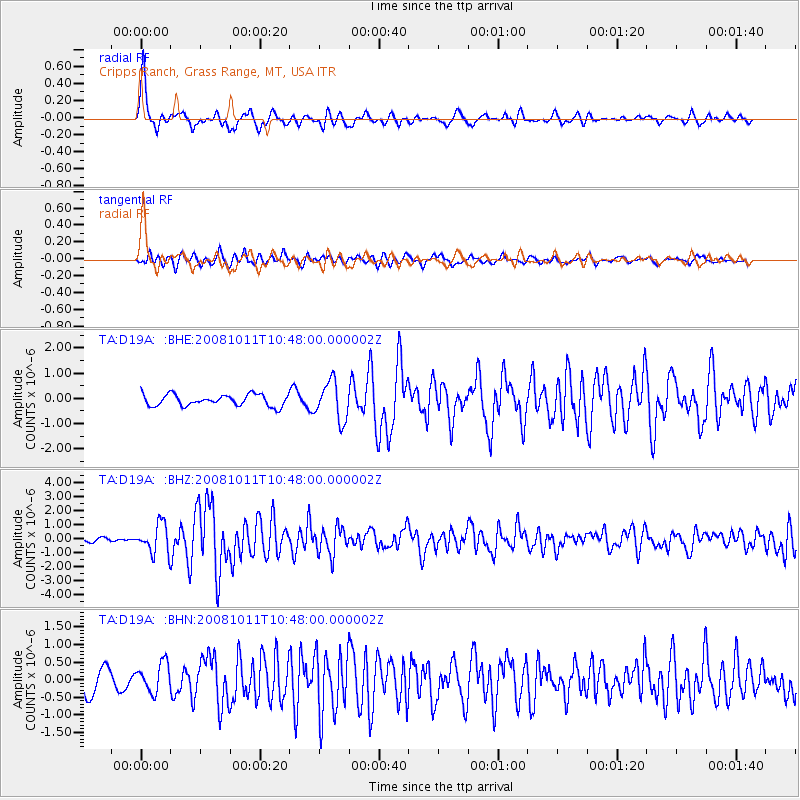
> Station D19A Cripps Ranch, Grass Range, MT, USA > Earthquake Result Viewer
D19A Cripps Ranch, Grass Range, MT, USA - Earthquake Result Viewer
| Earthquake location: |
Virgin Islands |
| Earthquake latitude/longitude: |
19.2/-64.8 |
| Earthquake time(UTC): |
2008/10/11 (285) 10:40:14 GMT |
| Earthquake Depth: |
23 km |
| Earthquake Magnitude: |
6.1 MB, 5.9 MS, 6.1 MW, 6.0 MW |
| Earthquake Catalog/Contributor: |
WHDF/NEIC |
|
| Network: |
TA USArray Transportable Network (new EarthScope stations) |
| Station: |
D19A Cripps Ranch, Grass Range, MT, USA |
| Lat/Lon: |
47.16 N/108.88 W |
| Elevation: |
1047 m |
|
| Distance: |
45.4 deg |
| Az: |
318.223 deg |
| Baz: |
112.637 deg |
| Ray Param: |
0.07126493 |
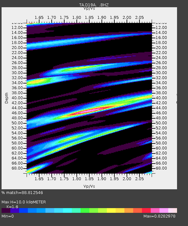
| Estimated Moho Depth: |
10.0 km |
| Estimated Crust Vp/Vs: |
1.60 |
| Assumed Crust Vp: |
6.518 km/s |
| Estimated Crust Vs: |
4.074 km/s |
| Estimated Crust Poisson's Ratio: |
0.18 |
|
| Radial Match: |
88.812546 % |
| Radial Bump: |
352 |
| Transverse Match: |
70.00389 % |
| Transverse Bump: |
400 |
| SOD ConfigId: |
2556 |
| Insert Time: |
2010-03-06 11:36:33.841 +0000 |
| GWidth: |
2.5 |
| Max Bumps: |
400 |
| Tol: |
0.001 |
|
Signal To Noise
| Channel | StoN | STA | LTA |
| TA:D19A: :BHZ:20081011T10:48:00.000002Z | 5.1705523 | 1.031309E-6 | 1.9945819E-7 |
| TA:D19A: :BHN:20081011T10:48:00.000002Z | 1.2424176 | 4.0981953E-7 | 3.298565E-7 |
| TA:D19A: :BHE:20081011T10:48:00.000002Z | 3.384091 | 7.6197284E-7 | 2.2516323E-7 |
| Arrivals |
| Ps | 1.0 SECOND |
| PpPs | 3.7 SECOND |
| PsPs/PpSs | 4.7 SECOND |


