You are here: Home > Network List > TA - USArray Transportable Network (new EarthScope stations) Stations List
> Station D19A Cripps Ranch, Grass Range, MT, USA > Earthquake Result Viewer
D19A Cripps Ranch, Grass Range, MT, USA - Earthquake Result Viewer
| Earthquake location: |
Near Coast Of Chiapas, Mexico |
| Earthquake latitude/longitude: |
14.4/-92.4 |
| Earthquake time(UTC): |
2008/10/16 (290) 19:41:25 GMT |
| Earthquake Depth: |
24 km |
| Earthquake Magnitude: |
6.1 MB, 6.6 MS, 6.7 MW, 6.6 MW |
| Earthquake Catalog/Contributor: |
WHDF/NEIC |
|
| Network: |
TA USArray Transportable Network (new EarthScope stations) |
| Station: |
D19A Cripps Ranch, Grass Range, MT, USA |
| Lat/Lon: |
47.16 N/108.88 W |
| Elevation: |
1047 m |
|
| Distance: |
35.4 deg |
| Az: |
340.453 deg |
| Baz: |
151.636 deg |
| Ray Param: |
0.077189624 |
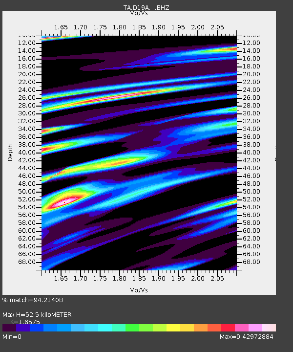
| Estimated Moho Depth: |
52.5 km |
| Estimated Crust Vp/Vs: |
1.66 |
| Assumed Crust Vp: |
6.518 km/s |
| Estimated Crust Vs: |
3.933 km/s |
| Estimated Crust Poisson's Ratio: |
0.21 |
|
| Radial Match: |
94.21408 % |
| Radial Bump: |
296 |
| Transverse Match: |
74.912186 % |
| Transverse Bump: |
400 |
| SOD ConfigId: |
2556 |
| Insert Time: |
2010-03-06 11:36:35.688 +0000 |
| GWidth: |
2.5 |
| Max Bumps: |
400 |
| Tol: |
0.001 |
|

Signal To Noise
| Channel | StoN | STA | LTA |
| TA:D19A: :BHZ:20081016T19:47:49.248992Z | 11.37395 | 2.5586612E-6 | 2.2495801E-7 |
| TA:D19A: :BHN:20081016T19:47:49.248992Z | 8.907568 | 1.7365767E-6 | 1.949552E-7 |
| TA:D19A: :BHE:20081016T19:47:49.248992Z | 5.117071 | 9.861229E-7 | 1.9271238E-7 |
| Arrivals |
| Ps | 5.8 SECOND |
| PpPs | 20 SECOND |
| PsPs/PpSs | 25 SECOND |


