You are here: Home > Network List > TA - USArray Transportable Network (new EarthScope stations) Stations List
> Station D19A Cripps Ranch, Grass Range, MT, USA > Earthquake Result Viewer
D19A Cripps Ranch, Grass Range, MT, USA - Earthquake Result Viewer
| Earthquake location: |
Santa Cruz Islands |
| Earthquake latitude/longitude: |
-11.6/166.1 |
| Earthquake time(UTC): |
2009/08/10 (222) 04:06:31 GMT |
| Earthquake Depth: |
35 km |
| Earthquake Magnitude: |
5.8 MB, 6.3 MS, 6.6 MW, 6.6 MW |
| Earthquake Catalog/Contributor: |
WHDF/NEIC |
|
| Network: |
TA USArray Transportable Network (new EarthScope stations) |
| Station: |
D19A Cripps Ranch, Grass Range, MT, USA |
| Lat/Lon: |
47.16 N/108.88 W |
| Elevation: |
1047 m |
|
| Distance: |
95.1 deg |
| Az: |
43.035 deg |
| Baz: |
258.504 deg |
| Ray Param: |
0.0408657 |
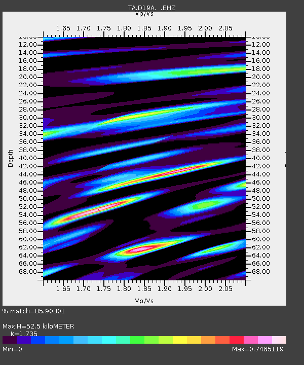
| Estimated Moho Depth: |
52.5 km |
| Estimated Crust Vp/Vs: |
1.74 |
| Assumed Crust Vp: |
6.518 km/s |
| Estimated Crust Vs: |
3.757 km/s |
| Estimated Crust Poisson's Ratio: |
0.25 |
|
| Radial Match: |
85.90301 % |
| Radial Bump: |
400 |
| Transverse Match: |
68.98167 % |
| Transverse Bump: |
400 |
| SOD ConfigId: |
2622 |
| Insert Time: |
2010-03-06 11:37:00.159 +0000 |
| GWidth: |
2.5 |
| Max Bumps: |
400 |
| Tol: |
0.001 |
|
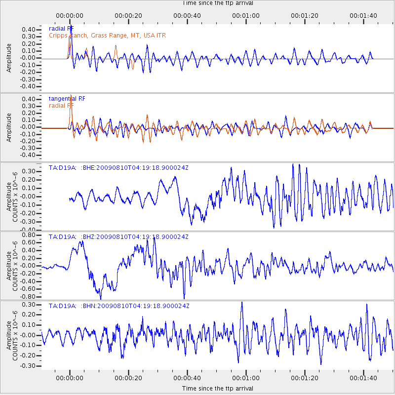
Signal To Noise
| Channel | StoN | STA | LTA |
| TA:D19A: :BHZ:20090810T04:19:18.900024Z | 9.315032 | 4.4758013E-7 | 4.804923E-8 |
| TA:D19A: :BHN:20090810T04:19:18.900024Z | 0.9974877 | 5.1096453E-8 | 5.1225147E-8 |
| TA:D19A: :BHE:20090810T04:19:18.900024Z | 2.395081 | 1.2989943E-7 | 5.4235926E-8 |
| Arrivals |
| Ps | 6.0 SECOND |
| PpPs | 22 SECOND |
| PsPs/PpSs | 28 SECOND |


