You are here: Home > Network List > TA - USArray Transportable Network (new EarthScope stations) Stations List
> Station TOLK Toolik Lake Research Station, AK, USA > Earthquake Result Viewer
TOLK Toolik Lake Research Station, AK, USA - Earthquake Result Viewer
| Earthquake location: |
Southeast Of Ryukyu Islands |
| Earthquake latitude/longitude: |
27.0/130.2 |
| Earthquake time(UTC): |
2016/05/27 (148) 03:44:29 GMT |
| Earthquake Depth: |
10 km |
| Earthquake Magnitude: |
5.8 MO |
| Earthquake Catalog/Contributor: |
NEIC PDE/NEIC ALERT |
|
| Network: |
TA USArray Transportable Network (new EarthScope stations) |
| Station: |
TOLK Toolik Lake Research Station, AK, USA |
| Lat/Lon: |
68.64 N/149.57 W |
| Elevation: |
760 m |
|
| Distance: |
61.6 deg |
| Az: |
24.229 deg |
| Baz: |
271.595 deg |
| Ray Param: |
0.06076321 |
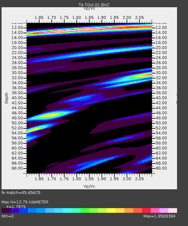
| Estimated Moho Depth: |
12.75 km |
| Estimated Crust Vp/Vs: |
1.80 |
| Assumed Crust Vp: |
6.316 km/s |
| Estimated Crust Vs: |
3.514 km/s |
| Estimated Crust Poisson's Ratio: |
0.28 |
|
| Radial Match: |
85.65625 % |
| Radial Bump: |
400 |
| Transverse Match: |
88.16335 % |
| Transverse Bump: |
400 |
| SOD ConfigId: |
1475611 |
| Insert Time: |
2016-06-10 03:49:48.183 +0000 |
| GWidth: |
2.5 |
| Max Bumps: |
400 |
| Tol: |
0.001 |
|
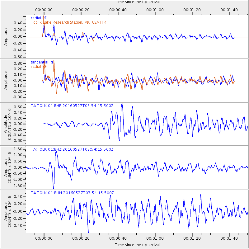
Signal To Noise
| Channel | StoN | STA | LTA |
| TA:TOLK:01:BHZ:20160527T03:54:15.500Z | 3.3528535 | 3.0221022E-7 | 9.013523E-8 |
| TA:TOLK:01:BHN:20160527T03:54:15.500Z | 0.8053209 | 3.137809E-8 | 3.896346E-8 |
| TA:TOLK:01:BHE:20160527T03:54:15.500Z | 1.6344796 | 8.005543E-8 | 4.897915E-8 |
| Arrivals |
| Ps | 1.7 SECOND |
| PpPs | 5.4 SECOND |
| PsPs/PpSs | 7.1 SECOND |


