You are here: Home > Network List > TA - USArray Transportable Network (new EarthScope stations) Stations List
> Station D19A Cripps Ranch, Grass Range, MT, USA > Earthquake Result Viewer
D19A Cripps Ranch, Grass Range, MT, USA - Earthquake Result Viewer

| Earthquake location: |
Kuril Islands |
| Earthquake latitude/longitude: |
48.3/154.2 |
| Earthquake time(UTC): |
2009/09/10 (253) 02:46:50 GMT |
| Earthquake Depth: |
36 km |
| Earthquake Magnitude: |
6.0 MB, 5.5 MS, 6.0 MW, 5.8 MW |
| Earthquake Catalog/Contributor: |
WHDF/NEIC |
|
| Network: |
TA USArray Transportable Network (new EarthScope stations) |
| Station: |
D19A Cripps Ranch, Grass Range, MT, USA |
| Lat/Lon: |
47.16 N/108.88 W |
| Elevation: |
1047 m |
|
| Distance: |
60.7 deg |
| Az: |
50.963 deg |
| Baz: |
310.55 deg |
| Ray Param: |
0.06129444 |
| Estimated Moho Depth: |
64.0 km |
| Estimated Crust Vp/Vs: |
1.63 |
| Assumed Crust Vp: |
6.518 km/s |
| Estimated Crust Vs: |
3.999 km/s |
| Estimated Crust Poisson's Ratio: |
0.20 |
|
| Radial Match: |
91.993614 % |
| Radial Bump: |
400 |
| Transverse Match: |
86.111374 % |
| Transverse Bump: |
400 |
| SOD ConfigId: |
2622 |
| Insert Time: |
2010-03-06 11:37:11.454 +0000 |
| GWidth: |
2.5 |
| Max Bumps: |
400 |
| Tol: |
0.001 |
|
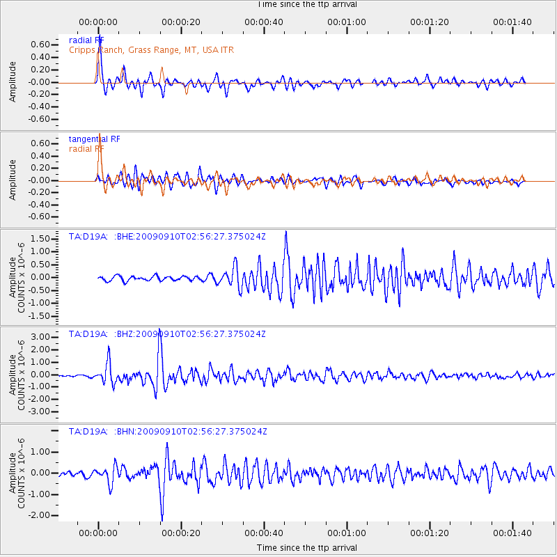
Signal To Noise
| Channel | StoN | STA | LTA |
| TA:D19A: :BHZ:20090910T02:56:27.375024Z | 11.968677 | 8.3546877E-7 | 6.980461E-8 |
| TA:D19A: :BHN:20090910T02:56:27.375024Z | 3.6786158 | 3.9908494E-7 | 1.08487804E-7 |
| TA:D19A: :BHE:20090910T02:56:27.375024Z | 4.611951 | 3.9377954E-7 | 8.5382425E-8 |
| Arrivals |
| Ps | 6.5 SECOND |
| PpPs | 25 SECOND |
| PsPs/PpSs | 31 SECOND |


