You are here: Home > Network List > TA - USArray Transportable Network (new EarthScope stations) Stations List
> Station D19A Cripps Ranch, Grass Range, MT, USA > Earthquake Result Viewer
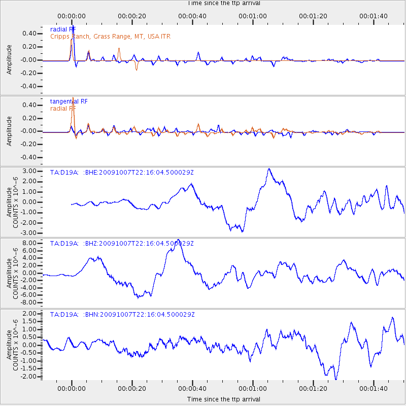
D19A Cripps Ranch, Grass Range, MT, USA - Earthquake Result Viewer

| Earthquake location: |
Vanuatu Islands |
| Earthquake latitude/longitude: |
-13.0/166.5 |
| Earthquake time(UTC): |
2009/10/07 (280) 22:03:14 GMT |
| Earthquake Depth: |
45 km |
| Earthquake Magnitude: |
6.4 MB, 7.3 MS, 7.6 MW, 7.7 MW |
| Earthquake Catalog/Contributor: |
WHDF/NEIC |
|
| Network: |
TA USArray Transportable Network (new EarthScope stations) |
| Station: |
D19A Cripps Ranch, Grass Range, MT, USA |
| Lat/Lon: |
47.16 N/108.88 W |
| Elevation: |
1047 m |
|
| Distance: |
95.8 deg |
| Az: |
43.065 deg |
| Baz: |
257.253 deg |
| Ray Param: |
0.040662937 |
| Estimated Moho Depth: |
52.0 km |
| Estimated Crust Vp/Vs: |
1.72 |
| Assumed Crust Vp: |
6.518 km/s |
| Estimated Crust Vs: |
3.801 km/s |
| Estimated Crust Poisson's Ratio: |
0.24 |
|
| Radial Match: |
93.45715 % |
| Radial Bump: |
284 |
| Transverse Match: |
80.35128 % |
| Transverse Bump: |
400 |
| SOD ConfigId: |
2622 |
| Insert Time: |
2010-03-06 11:37:19.705 +0000 |
| GWidth: |
2.5 |
| Max Bumps: |
400 |
| Tol: |
0.001 |
|
Signal To Noise
| Channel | StoN | STA | LTA |
| TA:D19A: :BHZ:20091007T22:16:04.500029Z | 7.459778 | 1.2045804E-6 | 1.614767E-7 |
| TA:D19A: :BHN:20091007T22:16:04.500029Z | 0.67034966 | 2.0124088E-7 | 3.0020286E-7 |
| TA:D19A: :BHE:20091007T22:16:04.500029Z | 1.892697 | 4.865946E-7 | 2.5709062E-7 |
| Arrivals |
| Ps | 5.8 SECOND |
| PpPs | 21 SECOND |
| PsPs/PpSs | 27 SECOND |


