You are here: Home > Network List > TA - USArray Transportable Network (new EarthScope stations) Stations List
> Station C16K Lisburne Hills, AK, USA > Earthquake Result Viewer
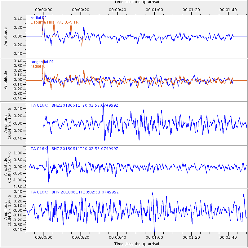
C16K Lisburne Hills, AK, USA - Earthquake Result Viewer
*The percent match for this event was below the threshold and hence no stack was calculated.
| Earthquake location: |
Kyushu, Japan |
| Earthquake latitude/longitude: |
31.3/131.5 |
| Earthquake time(UTC): |
2018/06/11 (162) 19:54:21 GMT |
| Earthquake Depth: |
34 km |
| Earthquake Magnitude: |
5.4 Mww |
| Earthquake Catalog/Contributor: |
NEIC PDE/us |
|
| Network: |
TA USArray Transportable Network (new EarthScope stations) |
| Station: |
C16K Lisburne Hills, AK, USA |
| Lat/Lon: |
68.27 N/165.34 W |
| Elevation: |
102 m |
|
| Distance: |
51.5 deg |
| Az: |
25.141 deg |
| Baz: |
257.731 deg |
| Ray Param: |
$rayparam |
*The percent match for this event was below the threshold and hence was not used in the summary stack. |
|
| Radial Match: |
70.7794 % |
| Radial Bump: |
400 |
| Transverse Match: |
69.427505 % |
| Transverse Bump: |
400 |
| SOD ConfigId: |
13570011 |
| Insert Time: |
2019-04-30 08:47:14.562 +0000 |
| GWidth: |
2.5 |
| Max Bumps: |
400 |
| Tol: |
0.001 |
|
Signal To Noise
| Channel | StoN | STA | LTA |
| TA:C16K: :BHZ:20180611T20:02:53.074999Z | 6.560895 | 5.51695E-7 | 8.408838E-8 |
| TA:C16K: :BHN:20180611T20:02:53.074999Z | 1.5886939 | 1.1857301E-7 | 7.463554E-8 |
| TA:C16K: :BHE:20180611T20:02:53.074999Z | 2.4090319 | 2.2468468E-7 | 9.326762E-8 |
| Arrivals |
| Ps | |
| PpPs | |
| PsPs/PpSs | |


