You are here: Home > Network List > TA - USArray Transportable Network (new EarthScope stations) Stations List
> Station F21K Alatna River, AK, USA > Earthquake Result Viewer
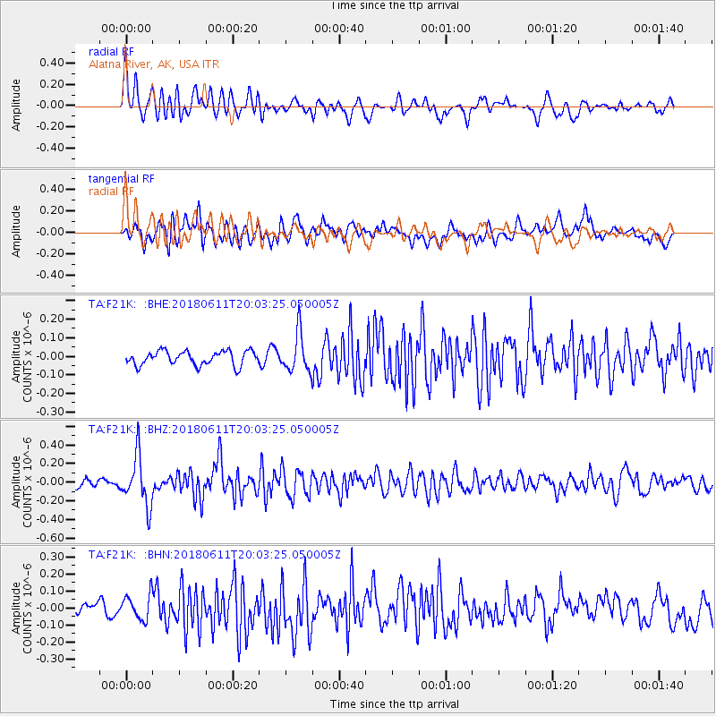
F21K Alatna River, AK, USA - Earthquake Result Viewer
*The percent match for this event was below the threshold and hence no stack was calculated.
| Earthquake location: |
Kyushu, Japan |
| Earthquake latitude/longitude: |
31.3/131.5 |
| Earthquake time(UTC): |
2018/06/11 (162) 19:54:21 GMT |
| Earthquake Depth: |
34 km |
| Earthquake Magnitude: |
5.4 Mww |
| Earthquake Catalog/Contributor: |
NEIC PDE/us |
|
| Network: |
TA USArray Transportable Network (new EarthScope stations) |
| Station: |
F21K Alatna River, AK, USA |
| Lat/Lon: |
67.22 N/153.48 W |
| Elevation: |
597 m |
|
| Distance: |
55.8 deg |
| Az: |
27.046 deg |
| Baz: |
269.834 deg |
| Ray Param: |
$rayparam |
*The percent match for this event was below the threshold and hence was not used in the summary stack. |
|
| Radial Match: |
74.539276 % |
| Radial Bump: |
400 |
| Transverse Match: |
48.13026 % |
| Transverse Bump: |
400 |
| SOD ConfigId: |
13570011 |
| Insert Time: |
2019-04-30 08:47:44.530 +0000 |
| GWidth: |
2.5 |
| Max Bumps: |
400 |
| Tol: |
0.001 |
|
Signal To Noise
| Channel | StoN | STA | LTA |
| TA:F21K: :BHZ:20180611T20:03:25.050005Z | 4.570702 | 2.7252628E-7 | 5.96246E-8 |
| TA:F21K: :BHN:20180611T20:03:25.050005Z | 1.0373992 | 7.638977E-8 | 7.3635846E-8 |
| TA:F21K: :BHE:20180611T20:03:25.050005Z | 2.813271 | 1.0731506E-7 | 3.814601E-8 |
| Arrivals |
| Ps | |
| PpPs | |
| PsPs/PpSs | |


