You are here: Home > Network List > TA - USArray Transportable Network (new EarthScope stations) Stations List
> Station F31M Tsiigehtchic, NWT, CAN > Earthquake Result Viewer
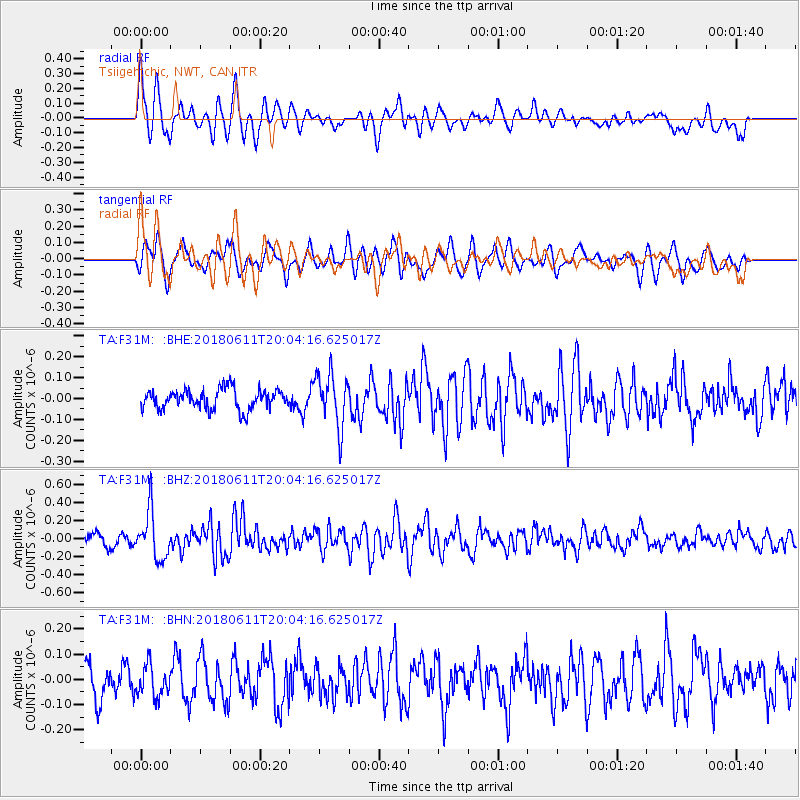
F31M Tsiigehtchic, NWT, CAN - Earthquake Result Viewer
*The percent match for this event was below the threshold and hence no stack was calculated.
| Earthquake location: |
Kyushu, Japan |
| Earthquake latitude/longitude: |
31.3/131.5 |
| Earthquake time(UTC): |
2018/06/11 (162) 19:54:21 GMT |
| Earthquake Depth: |
34 km |
| Earthquake Magnitude: |
5.4 Mww |
| Earthquake Catalog/Contributor: |
NEIC PDE/us |
|
| Network: |
TA USArray Transportable Network (new EarthScope stations) |
| Station: |
F31M Tsiigehtchic, NWT, CAN |
| Lat/Lon: |
67.44 N/133.74 W |
| Elevation: |
56 m |
|
| Distance: |
63.3 deg |
| Az: |
25.485 deg |
| Baz: |
287.266 deg |
| Ray Param: |
$rayparam |
*The percent match for this event was below the threshold and hence was not used in the summary stack. |
|
| Radial Match: |
70.47424 % |
| Radial Bump: |
400 |
| Transverse Match: |
69.12359 % |
| Transverse Bump: |
400 |
| SOD ConfigId: |
13570011 |
| Insert Time: |
2019-04-30 08:47:49.499 +0000 |
| GWidth: |
2.5 |
| Max Bumps: |
400 |
| Tol: |
0.001 |
|
Signal To Noise
| Channel | StoN | STA | LTA |
| TA:F31M: :BHZ:20180611T20:04:16.625017Z | 4.562061 | 2.6366706E-7 | 5.7795603E-8 |
| TA:F31M: :BHN:20180611T20:04:16.625017Z | 1.0589232 | 6.280633E-8 | 5.9311503E-8 |
| TA:F31M: :BHE:20180611T20:04:16.625017Z | 2.5847456 | 1.2508613E-7 | 4.8393982E-8 |
| Arrivals |
| Ps | |
| PpPs | |
| PsPs/PpSs | |


