You are here: Home > Network List > TA - USArray Transportable Network (new EarthScope stations) Stations List
> Station G31M Satah River, YT, CAN > Earthquake Result Viewer
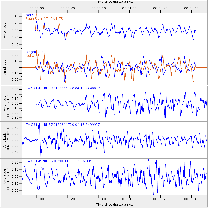
G31M Satah River, YT, CAN - Earthquake Result Viewer
*The percent match for this event was below the threshold and hence no stack was calculated.
| Earthquake location: |
Kyushu, Japan |
| Earthquake latitude/longitude: |
31.3/131.5 |
| Earthquake time(UTC): |
2018/06/11 (162) 19:54:21 GMT |
| Earthquake Depth: |
34 km |
| Earthquake Magnitude: |
5.4 Mww |
| Earthquake Catalog/Contributor: |
NEIC PDE/us |
|
| Network: |
TA USArray Transportable Network (new EarthScope stations) |
| Station: |
G31M Satah River, YT, CAN |
| Lat/Lon: |
66.92 N/134.27 W |
| Elevation: |
61 m |
|
| Distance: |
63.3 deg |
| Az: |
26.11 deg |
| Baz: |
287.06 deg |
| Ray Param: |
$rayparam |
*The percent match for this event was below the threshold and hence was not used in the summary stack. |
|
| Radial Match: |
58.491657 % |
| Radial Bump: |
400 |
| Transverse Match: |
56.91819 % |
| Transverse Bump: |
400 |
| SOD ConfigId: |
13570011 |
| Insert Time: |
2019-04-30 08:48:00.045 +0000 |
| GWidth: |
2.5 |
| Max Bumps: |
400 |
| Tol: |
0.001 |
|
Signal To Noise
| Channel | StoN | STA | LTA |
| TA:G31M: :BHZ:20180611T20:04:16.349993Z | 3.840429 | 2.612726E-7 | 6.803213E-8 |
| TA:G31M: :BHN:20180611T20:04:16.349993Z | 1.5568634 | 1.3224656E-7 | 8.4944226E-8 |
| TA:G31M: :BHE:20180611T20:04:16.349993Z | 1.9250199 | 1.0536887E-7 | 5.4736507E-8 |
| Arrivals |
| Ps | |
| PpPs | |
| PsPs/PpSs | |


