You are here: Home > Network List > US - United States National Seismic Network Stations List
> Station NEW Newport, Washington, USA > Earthquake Result Viewer
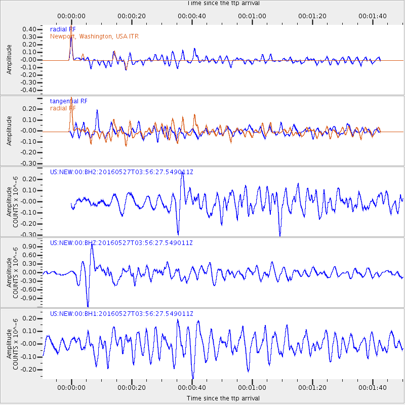
NEW Newport, Washington, USA - Earthquake Result Viewer
*The percent match for this event was below the threshold and hence no stack was calculated.
| Earthquake location: |
Southeast Of Ryukyu Islands |
| Earthquake latitude/longitude: |
27.0/130.2 |
| Earthquake time(UTC): |
2016/05/27 (148) 03:44:29 GMT |
| Earthquake Depth: |
10 km |
| Earthquake Magnitude: |
5.8 MO |
| Earthquake Catalog/Contributor: |
NEIC PDE/NEIC ALERT |
|
| Network: |
US United States National Seismic Network |
| Station: |
NEW Newport, Washington, USA |
| Lat/Lon: |
48.26 N/117.12 W |
| Elevation: |
760 m |
|
| Distance: |
83.9 deg |
| Az: |
38.315 deg |
| Baz: |
304.11 deg |
| Ray Param: |
$rayparam |
*The percent match for this event was below the threshold and hence was not used in the summary stack. |
|
| Radial Match: |
72.20301 % |
| Radial Bump: |
400 |
| Transverse Match: |
73.12271 % |
| Transverse Bump: |
400 |
| SOD ConfigId: |
1475611 |
| Insert Time: |
2016-06-10 03:50:55.594 +0000 |
| GWidth: |
2.5 |
| Max Bumps: |
400 |
| Tol: |
0.001 |
|
Signal To Noise
| Channel | StoN | STA | LTA |
| US:NEW:00:BHZ:20160527T03:56:27.549011Z | 5.166005 | 2.3976438E-7 | 4.6411955E-8 |
| US:NEW:00:BH1:20160527T03:56:27.549011Z | 0.9384053 | 3.4747494E-8 | 3.7028236E-8 |
| US:NEW:00:BH2:20160527T03:56:27.549011Z | 1.24896 | 5.3885717E-8 | 4.3144468E-8 |
| Arrivals |
| Ps | |
| PpPs | |
| PsPs/PpSs | |


