You are here: Home > Network List > TA - USArray Transportable Network (new EarthScope stations) Stations List
> Station M31M Drury Creek, Yukon, CA > Earthquake Result Viewer
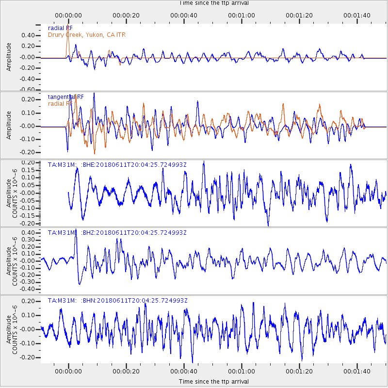
M31M Drury Creek, Yukon, CA - Earthquake Result Viewer
*The percent match for this event was below the threshold and hence no stack was calculated.
| Earthquake location: |
Kyushu, Japan |
| Earthquake latitude/longitude: |
31.3/131.5 |
| Earthquake time(UTC): |
2018/06/11 (162) 19:54:21 GMT |
| Earthquake Depth: |
34 km |
| Earthquake Magnitude: |
5.4 Mww |
| Earthquake Catalog/Contributor: |
NEIC PDE/us |
|
| Network: |
TA USArray Transportable Network (new EarthScope stations) |
| Station: |
M31M Drury Creek, Yukon, CA |
| Lat/Lon: |
62.20 N/134.39 W |
| Elevation: |
639 m |
|
| Distance: |
64.7 deg |
| Az: |
31.141 deg |
| Baz: |
289.159 deg |
| Ray Param: |
$rayparam |
*The percent match for this event was below the threshold and hence was not used in the summary stack. |
|
| Radial Match: |
52.532833 % |
| Radial Bump: |
400 |
| Transverse Match: |
49.55817 % |
| Transverse Bump: |
400 |
| SOD ConfigId: |
13570011 |
| Insert Time: |
2019-04-30 08:48:43.497 +0000 |
| GWidth: |
2.5 |
| Max Bumps: |
400 |
| Tol: |
0.001 |
|
Signal To Noise
| Channel | StoN | STA | LTA |
| TA:M31M: :BHZ:20180611T20:04:25.724993Z | 3.5657947 | 2.0251146E-7 | 5.67928E-8 |
| TA:M31M: :BHN:20180611T20:04:25.724993Z | 1.30982 | 7.3374345E-8 | 5.6018646E-8 |
| TA:M31M: :BHE:20180611T20:04:25.724993Z | 0.9260107 | 6.1220355E-8 | 6.611192E-8 |
| Arrivals |
| Ps | |
| PpPs | |
| PsPs/PpSs | |


