You are here: Home > Network List > US - United States National Seismic Network Stations List
> Station TPNV Topopah Spring, Nevada, USA > Earthquake Result Viewer
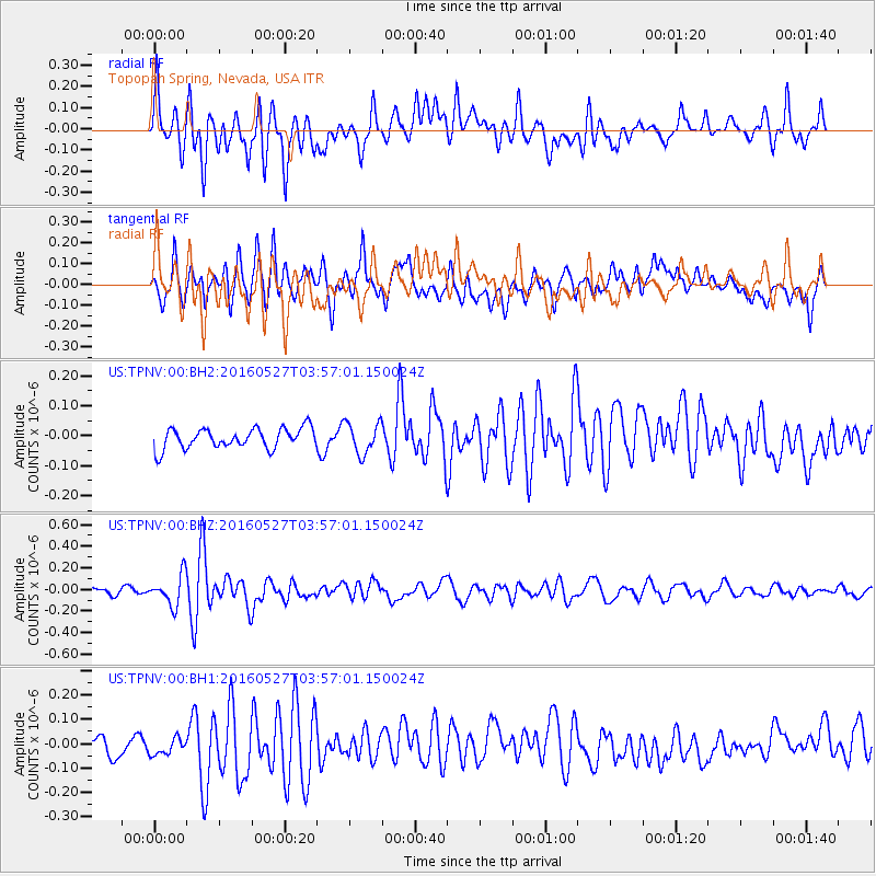
TPNV Topopah Spring, Nevada, USA - Earthquake Result Viewer
*The percent match for this event was below the threshold and hence no stack was calculated.
| Earthquake location: |
Southeast Of Ryukyu Islands |
| Earthquake latitude/longitude: |
27.0/130.2 |
| Earthquake time(UTC): |
2016/05/27 (148) 03:44:29 GMT |
| Earthquake Depth: |
10 km |
| Earthquake Magnitude: |
5.8 MO |
| Earthquake Catalog/Contributor: |
NEIC PDE/NEIC ALERT |
|
| Network: |
US United States National Seismic Network |
| Station: |
TPNV Topopah Spring, Nevada, USA |
| Lat/Lon: |
36.95 N/116.25 W |
| Elevation: |
1600 m |
|
| Distance: |
90.9 deg |
| Az: |
47.26 deg |
| Baz: |
305.107 deg |
| Ray Param: |
$rayparam |
*The percent match for this event was below the threshold and hence was not used in the summary stack. |
|
| Radial Match: |
73.10926 % |
| Radial Bump: |
400 |
| Transverse Match: |
72.6267 % |
| Transverse Bump: |
400 |
| SOD ConfigId: |
1475611 |
| Insert Time: |
2016-06-10 03:51:11.502 +0000 |
| GWidth: |
2.5 |
| Max Bumps: |
400 |
| Tol: |
0.001 |
|
Signal To Noise
| Channel | StoN | STA | LTA |
| US:TPNV:00:BHZ:20160527T03:57:01.150024Z | 4.5436273 | 1.4120634E-7 | 3.107789E-8 |
| US:TPNV:00:BH1:20160527T03:57:01.150024Z | 0.91821903 | 3.7284543E-8 | 4.0605283E-8 |
| US:TPNV:00:BH2:20160527T03:57:01.150024Z | 1.5332054 | 5.1779917E-8 | 3.377233E-8 |
| Arrivals |
| Ps | |
| PpPs | |
| PsPs/PpSs | |


