You are here: Home > Network List > TA - USArray Transportable Network (new EarthScope stations) Stations List
> Station MDND Maddock, ND, USA > Earthquake Result Viewer
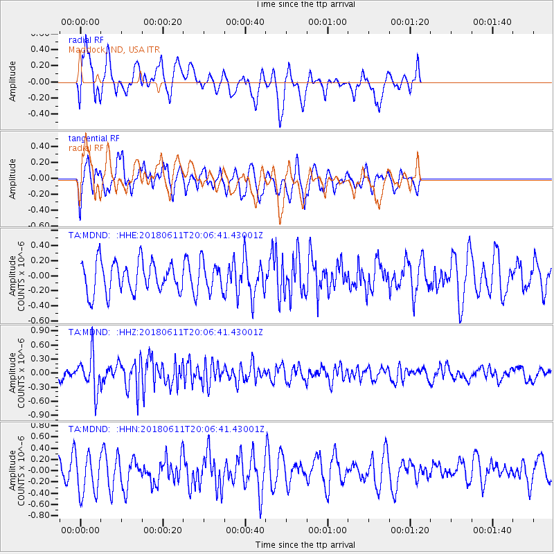
MDND Maddock, ND, USA - Earthquake Result Viewer
*The percent match for this event was below the threshold and hence no stack was calculated.
| Earthquake location: |
Kyushu, Japan |
| Earthquake latitude/longitude: |
31.3/131.5 |
| Earthquake time(UTC): |
2018/06/11 (162) 19:54:21 GMT |
| Earthquake Depth: |
34 km |
| Earthquake Magnitude: |
5.4 Mww |
| Earthquake Catalog/Contributor: |
NEIC PDE/us |
|
| Network: |
TA USArray Transportable Network (new EarthScope stations) |
| Station: |
MDND Maddock, ND, USA |
| Lat/Lon: |
47.85 N/99.60 W |
| Elevation: |
479 m |
|
| Distance: |
88.9 deg |
| Az: |
31.607 deg |
| Baz: |
318.22 deg |
| Ray Param: |
$rayparam |
*The percent match for this event was below the threshold and hence was not used in the summary stack. |
|
| Radial Match: |
53.559284 % |
| Radial Bump: |
400 |
| Transverse Match: |
60.71256 % |
| Transverse Bump: |
400 |
| SOD ConfigId: |
13570011 |
| Insert Time: |
2019-04-30 08:48:45.101 +0000 |
| GWidth: |
2.5 |
| Max Bumps: |
400 |
| Tol: |
0.001 |
|
Signal To Noise
| Channel | StoN | STA | LTA |
| TA:MDND: :HHZ:20180611T20:06:41.43001Z | 4.704036 | 4.0155527E-7 | 8.5363986E-8 |
| TA:MDND: :HHN:20180611T20:06:41.43001Z | 2.1812236 | 3.976796E-7 | 1.823195E-7 |
| TA:MDND: :HHE:20180611T20:06:41.43001Z | 0.93977994 | 1.9136866E-7 | 2.0363136E-7 |
| Arrivals |
| Ps | |
| PpPs | |
| PsPs/PpSs | |


