You are here: Home > Network List > TA - USArray Transportable Network (new EarthScope stations) Stations List
> Station D19A Cripps Ranch, Grass Range, MT, USA > Earthquake Result Viewer
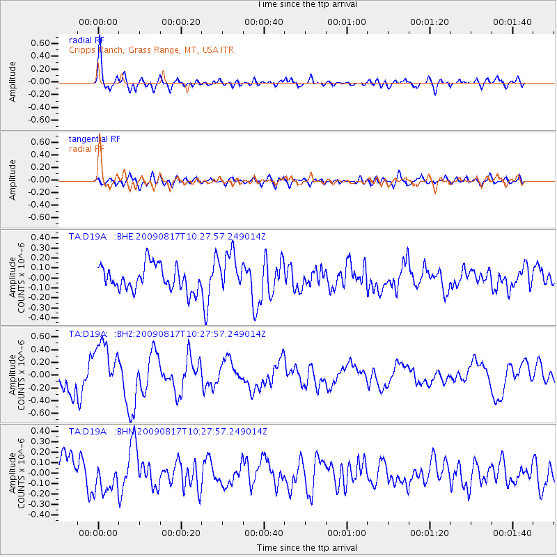
D19A Cripps Ranch, Grass Range, MT, USA - Earthquake Result Viewer
*The percent match for this event was below the threshold and hence no stack was calculated.
| Earthquake location: |
Southwestern Ryukyu Isl., Japan |
| Earthquake latitude/longitude: |
23.4/123.7 |
| Earthquake time(UTC): |
2009/08/17 (229) 10:15:05 GMT |
| Earthquake Depth: |
10 km |
| Earthquake Magnitude: |
5.7 MB |
| Earthquake Catalog/Contributor: |
WHDF/NEIC |
|
| Network: |
TA USArray Transportable Network (new EarthScope stations) |
| Station: |
D19A Cripps Ranch, Grass Range, MT, USA |
| Lat/Lon: |
47.16 N/108.88 W |
| Elevation: |
1047 m |
|
| Distance: |
95.3 deg |
| Az: |
32.977 deg |
| Baz: |
312.882 deg |
| Ray Param: |
$rayparam |
*The percent match for this event was below the threshold and hence was not used in the summary stack. |
|
| Radial Match: |
79.48927 % |
| Radial Bump: |
400 |
| Transverse Match: |
50.36389 % |
| Transverse Bump: |
400 |
| SOD ConfigId: |
2622 |
| Insert Time: |
2010-03-06 11:38:20.121 +0000 |
| GWidth: |
2.5 |
| Max Bumps: |
400 |
| Tol: |
0.001 |
|
Signal To Noise
| Channel | StoN | STA | LTA |
| TA:D19A: :BHZ:20090817T10:27:57.249014Z | 1.7684941 | 4.2239873E-7 | 2.3884655E-7 |
| TA:D19A: :BHN:20090817T10:27:57.249014Z | 1.1610867 | 1.4792082E-7 | 1.273986E-7 |
| TA:D19A: :BHE:20090817T10:27:57.249014Z | 1.566426 | 1.9376103E-7 | 1.2369625E-7 |
| Arrivals |
| Ps | |
| PpPs | |
| PsPs/PpSs | |


