You are here: Home > Network List > TA - USArray Transportable Network (new EarthScope stations) Stations List
> Station T25A Trinidad, CO, USA > Earthquake Result Viewer
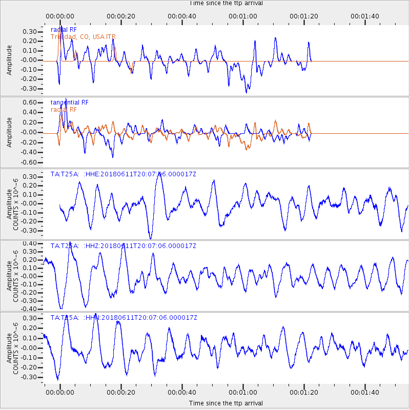
T25A Trinidad, CO, USA - Earthquake Result Viewer
*The percent match for this event was below the threshold and hence no stack was calculated.
| Earthquake location: |
Kyushu, Japan |
| Earthquake latitude/longitude: |
31.3/131.5 |
| Earthquake time(UTC): |
2018/06/11 (162) 19:54:21 GMT |
| Earthquake Depth: |
34 km |
| Earthquake Magnitude: |
5.4 Mww |
| Earthquake Catalog/Contributor: |
NEIC PDE/us |
|
| Network: |
TA USArray Transportable Network (new EarthScope stations) |
| Station: |
T25A Trinidad, CO, USA |
| Lat/Lon: |
37.14 N/104.41 W |
| Elevation: |
2017 m |
|
| Distance: |
94.2 deg |
| Az: |
41.556 deg |
| Baz: |
314.698 deg |
| Ray Param: |
$rayparam |
*The percent match for this event was below the threshold and hence was not used in the summary stack. |
|
| Radial Match: |
57.140152 % |
| Radial Bump: |
400 |
| Transverse Match: |
74.95262 % |
| Transverse Bump: |
400 |
| SOD ConfigId: |
13570011 |
| Insert Time: |
2019-04-30 08:49:09.906 +0000 |
| GWidth: |
2.5 |
| Max Bumps: |
400 |
| Tol: |
0.001 |
|
Signal To Noise
| Channel | StoN | STA | LTA |
| TA:T25A: :HHZ:20180611T20:07:06.000017Z | 2.1377163 | 2.8333383E-7 | 1.3254044E-7 |
| TA:T25A: :HHN:20180611T20:07:06.000017Z | 1.5343138 | 2.037183E-7 | 1.3277486E-7 |
| TA:T25A: :HHE:20180611T20:07:06.000017Z | 2.306881 | 2.659649E-7 | 1.1529199E-7 |
| Arrivals |
| Ps | |
| PpPs | |
| PsPs/PpSs | |


