You are here: Home > Network List > TA - USArray Transportable Network (new EarthScope stations) Stations List
> Station D19A Cripps Ranch, Grass Range, MT, USA > Earthquake Result Viewer
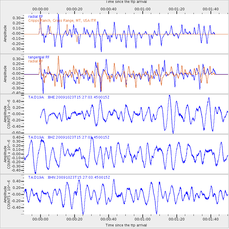
D19A Cripps Ranch, Grass Range, MT, USA - Earthquake Result Viewer
*The percent match for this event was below the threshold and hence no stack was calculated.
| Earthquake location: |
Santa Cruz Islands |
| Earthquake latitude/longitude: |
-12.2/166.0 |
| Earthquake time(UTC): |
2009/10/23 (296) 15:14:13 GMT |
| Earthquake Depth: |
31 km |
| Earthquake Magnitude: |
5.6 MB, 5.8 MS, 6.0 MW, 5.9 MW |
| Earthquake Catalog/Contributor: |
WHDF/NEIC |
|
| Network: |
TA USArray Transportable Network (new EarthScope stations) |
| Station: |
D19A Cripps Ranch, Grass Range, MT, USA |
| Lat/Lon: |
47.16 N/108.88 W |
| Elevation: |
1047 m |
|
| Distance: |
95.5 deg |
| Az: |
43.078 deg |
| Baz: |
258.137 deg |
| Ray Param: |
$rayparam |
*The percent match for this event was below the threshold and hence was not used in the summary stack. |
|
| Radial Match: |
60.889942 % |
| Radial Bump: |
400 |
| Transverse Match: |
64.95135 % |
| Transverse Bump: |
400 |
| SOD ConfigId: |
2622 |
| Insert Time: |
2010-03-06 11:38:42.061 +0000 |
| GWidth: |
2.5 |
| Max Bumps: |
400 |
| Tol: |
0.001 |
|
Signal To Noise
| Channel | StoN | STA | LTA |
| TA:D19A: :BHZ:20091023T15:27:03.450015Z | 2.4478421 | 2.6928916E-7 | 1.1001084E-7 |
| TA:D19A: :BHN:20091023T15:27:03.450015Z | 0.71068424 | 1.00995436E-7 | 1.4211014E-7 |
| TA:D19A: :BHE:20091023T15:27:03.450015Z | 2.1587899 | 2.3783976E-7 | 1.1017272E-7 |
| Arrivals |
| Ps | |
| PpPs | |
| PsPs/PpSs | |


