You are here: Home > Network List > CB - China National Seismic Network Stations List
> Station HEH Heihe,Heilongjiang Province > Earthquake Result Viewer
HEH Heihe,Heilongjiang Province - Earthquake Result Viewer
| Earthquake location: |
Southwest Of Sumatra, Indonesia |
| Earthquake latitude/longitude: |
-2.1/98.5 |
| Earthquake time(UTC): |
2018/06/12 (163) 23:08:28 GMT |
| Earthquake Depth: |
10 km |
| Earthquake Magnitude: |
5.8 Mww |
| Earthquake Catalog/Contributor: |
NEIC PDE/us |
|
| Network: |
CB China National Seismic Network |
| Station: |
HEH Heihe,Heilongjiang Province |
| Lat/Lon: |
50.25 N/127.41 E |
| Elevation: |
165 m |
|
| Distance: |
57.7 deg |
| Az: |
21.515 deg |
| Baz: |
214.816 deg |
| Ray Param: |
0.06329861 |
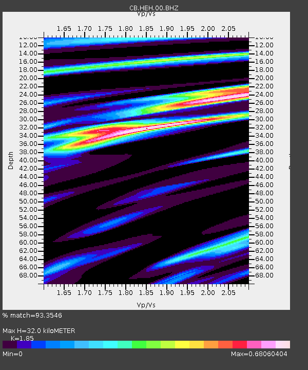
| Estimated Moho Depth: |
32.0 km |
| Estimated Crust Vp/Vs: |
1.85 |
| Assumed Crust Vp: |
6.419 km/s |
| Estimated Crust Vs: |
3.47 km/s |
| Estimated Crust Poisson's Ratio: |
0.29 |
|
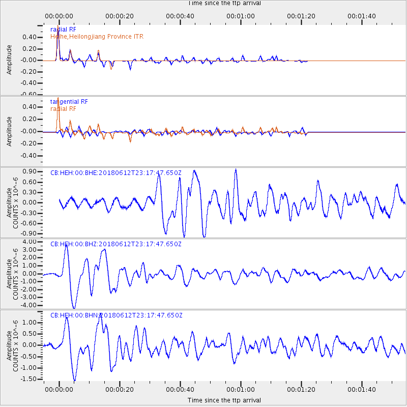
| Radial Match: |
93.3546 % |
| Radial Bump: |
212 |
| Transverse Match: |
69.77272 % |
| Transverse Bump: |
400 |
| SOD ConfigId: |
13570011 |
| Insert Time: |
2019-04-30 08:56:52.800 +0000 |
| GWidth: |
2.5 |
| Max Bumps: |
400 |
| Tol: |
0.001 |
|
Signal To Noise
| Channel | StoN | STA | LTA |
| CB:HEH:00:BHZ:20180612T23:17:47.650Z | 16.001148 | 2.2818788E-6 | 1.4260718E-7 |
| CB:HEH:00:BHN:20180612T23:17:47.650Z | 7.516111 | 7.3891977E-7 | 9.831145E-8 |
| CB:HEH:00:BHE:20180612T23:17:47.650Z | 4.4801164 | 4.862906E-7 | 1.08544185E-7 |
| Arrivals |
| Ps | 4.4 SECOND |
| PpPs | 14 SECOND |
| PsPs/PpSs | 18 SECOND |


