You are here: Home > Network List > KR - Kyrgyz Digital Network Stations List
> Station BTK Batken, Kyrgyzstan > Earthquake Result Viewer
BTK Batken, Kyrgyzstan - Earthquake Result Viewer
| Earthquake location: |
Southwest Of Sumatra, Indonesia |
| Earthquake latitude/longitude: |
-2.1/98.5 |
| Earthquake time(UTC): |
2018/06/12 (163) 23:08:28 GMT |
| Earthquake Depth: |
10 km |
| Earthquake Magnitude: |
5.8 Mww |
| Earthquake Catalog/Contributor: |
NEIC PDE/us |
|
| Network: |
KR Kyrgyz Digital Network |
| Station: |
BTK Batken, Kyrgyzstan |
| Lat/Lon: |
40.06 N/70.82 E |
| Elevation: |
980 m |
|
| Distance: |
49.0 deg |
| Az: |
331.8 deg |
| Baz: |
142.026 deg |
| Ray Param: |
0.06897066 |
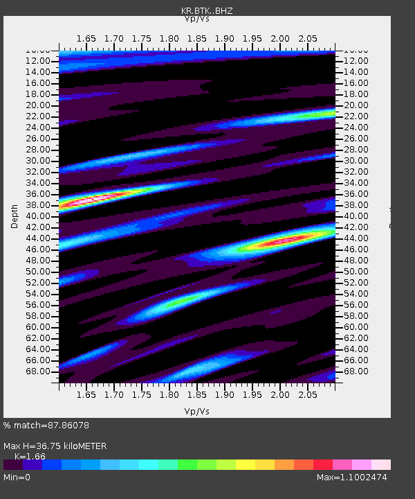
| Estimated Moho Depth: |
36.75 km |
| Estimated Crust Vp/Vs: |
1.66 |
| Assumed Crust Vp: |
6.236 km/s |
| Estimated Crust Vs: |
3.757 km/s |
| Estimated Crust Poisson's Ratio: |
0.22 |
|
| Radial Match: |
87.86078 % |
| Radial Bump: |
400 |
| Transverse Match: |
88.83564 % |
| Transverse Bump: |
400 |
| SOD ConfigId: |
13570011 |
| Insert Time: |
2019-04-30 08:57:50.528 +0000 |
| GWidth: |
2.5 |
| Max Bumps: |
400 |
| Tol: |
0.001 |
|

Signal To Noise
| Channel | StoN | STA | LTA |
| KR:BTK: :BHZ:20180612T23:16:44.125006Z | 13.715771 | 8.244924E-7 | 6.011273E-8 |
| KR:BTK: :BHN:20180612T23:16:44.125006Z | 6.019961 | 2.872233E-7 | 4.771182E-8 |
| KR:BTK: :BHE:20180612T23:16:44.125006Z | 4.072578 | 1.5743319E-7 | 3.865689E-8 |
| Arrivals |
| Ps | 4.1 SECOND |
| PpPs | 15 SECOND |
| PsPs/PpSs | 19 SECOND |


