You are here: Home > Network List > KZ - Kazakhstan Network Stations List
> Station MAKZ Makanchi, Kazakstan > Earthquake Result Viewer
MAKZ Makanchi, Kazakstan - Earthquake Result Viewer
| Earthquake location: |
Southwest Of Sumatra, Indonesia |
| Earthquake latitude/longitude: |
-2.1/98.5 |
| Earthquake time(UTC): |
2018/06/12 (163) 23:08:28 GMT |
| Earthquake Depth: |
10 km |
| Earthquake Magnitude: |
5.8 Mww |
| Earthquake Catalog/Contributor: |
NEIC PDE/us |
|
| Network: |
KZ Kazakhstan Network |
| Station: |
MAKZ Makanchi, Kazakstan |
| Lat/Lon: |
46.81 N/81.98 E |
| Elevation: |
600 m |
|
| Distance: |
50.8 deg |
| Az: |
345.389 deg |
| Baz: |
158.469 deg |
| Ray Param: |
0.06779098 |
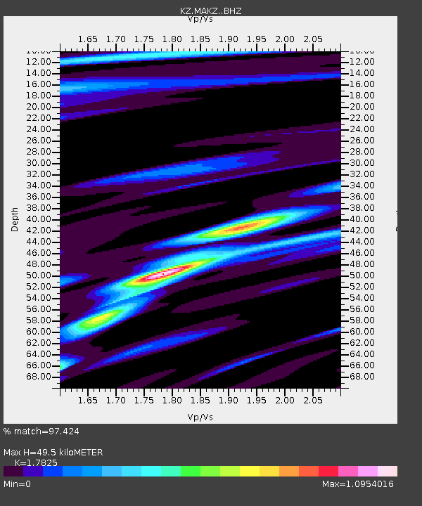
| Estimated Moho Depth: |
49.5 km |
| Estimated Crust Vp/Vs: |
1.78 |
| Assumed Crust Vp: |
6.571 km/s |
| Estimated Crust Vs: |
3.686 km/s |
| Estimated Crust Poisson's Ratio: |
0.27 |
|
| Radial Match: |
97.424 % |
| Radial Bump: |
315 |
| Transverse Match: |
83.62056 % |
| Transverse Bump: |
400 |
| SOD ConfigId: |
13570011 |
| Insert Time: |
2019-04-30 08:58:03.250 +0000 |
| GWidth: |
2.5 |
| Max Bumps: |
400 |
| Tol: |
0.001 |
|

Signal To Noise
| Channel | StoN | STA | LTA |
| KZ:MAKZ: :BHZ:20180612T23:16:57.694006Z | 20.61686 | 1.1089714E-6 | 5.378954E-8 |
| KZ:MAKZ: :BHN:20180612T23:16:57.694006Z | 24.969742 | 4.7667444E-7 | 1.9090084E-8 |
| KZ:MAKZ: :BHE:20180612T23:16:57.694006Z | 7.559188 | 2.0257882E-7 | 2.6799018E-8 |
| Arrivals |
| Ps | 6.3 SECOND |
| PpPs | 20 SECOND |
| PsPs/PpSs | 26 SECOND |


