You are here: Home > Network List > TA - USArray Transportable Network (new EarthScope stations) Stations List
> Station E20K Nigu River, AK, USA > Earthquake Result Viewer
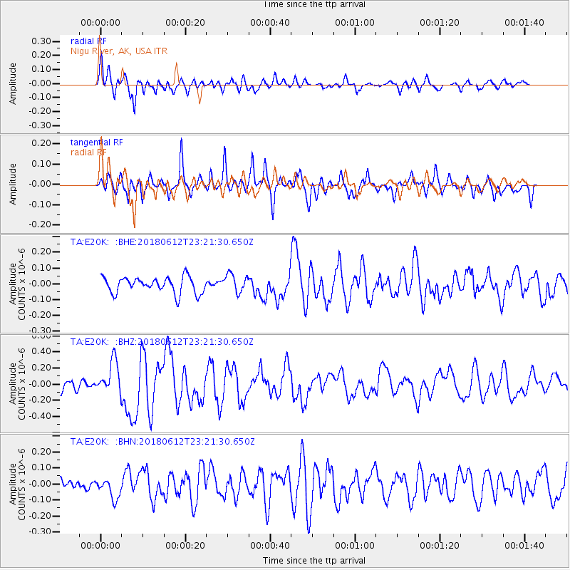
E20K Nigu River, AK, USA - Earthquake Result Viewer
*The percent match for this event was below the threshold and hence no stack was calculated.
| Earthquake location: |
Southwest Of Sumatra, Indonesia |
| Earthquake latitude/longitude: |
-2.1/98.5 |
| Earthquake time(UTC): |
2018/06/12 (163) 23:08:28 GMT |
| Earthquake Depth: |
10 km |
| Earthquake Magnitude: |
5.8 Mww |
| Earthquake Catalog/Contributor: |
NEIC PDE/us |
|
| Network: |
TA USArray Transportable Network (new EarthScope stations) |
| Station: |
E20K Nigu River, AK, USA |
| Lat/Lon: |
68.26 N/156.19 W |
| Elevation: |
866 m |
|
| Distance: |
97.6 deg |
| Az: |
21.258 deg |
| Baz: |
283.477 deg |
| Ray Param: |
$rayparam |
*The percent match for this event was below the threshold and hence was not used in the summary stack. |
|
| Radial Match: |
75.22007 % |
| Radial Bump: |
400 |
| Transverse Match: |
75.61049 % |
| Transverse Bump: |
400 |
| SOD ConfigId: |
13570011 |
| Insert Time: |
2019-04-30 08:58:55.133 +0000 |
| GWidth: |
2.5 |
| Max Bumps: |
400 |
| Tol: |
0.001 |
|
Signal To Noise
| Channel | StoN | STA | LTA |
| TA:E20K: :BHZ:20180612T23:21:30.650Z | 2.3721452 | 2.1153834E-7 | 8.917597E-8 |
| TA:E20K: :BHN:20180612T23:21:30.650Z | 1.2937686 | 6.576937E-8 | 5.0835496E-8 |
| TA:E20K: :BHE:20180612T23:21:30.650Z | 1.1690454 | 5.961557E-8 | 5.0995087E-8 |
| Arrivals |
| Ps | |
| PpPs | |
| PsPs/PpSs | |


