You are here: Home > Network List > TA - USArray Transportable Network (new EarthScope stations) Stations List
> Station C16K Lisburne Hills, AK, USA > Earthquake Result Viewer
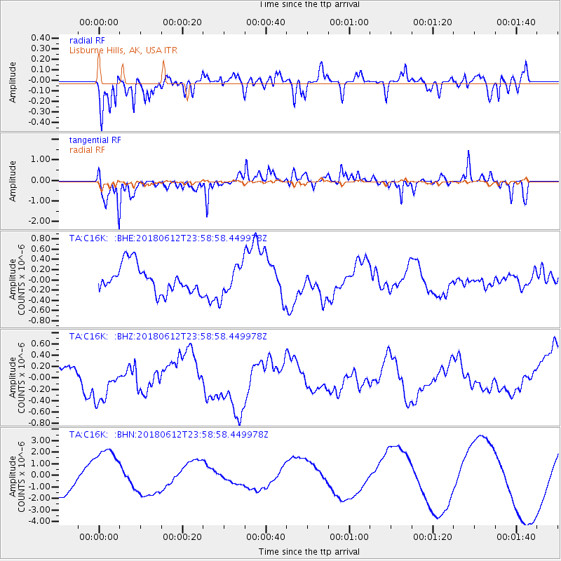
C16K Lisburne Hills, AK, USA - Earthquake Result Viewer
*The percent match for this event was below the threshold and hence no stack was calculated.
| Earthquake location: |
Southern Sumatra, Indonesia |
| Earthquake latitude/longitude: |
-1.9/98.7 |
| Earthquake time(UTC): |
2018/06/12 (163) 23:46:12 GMT |
| Earthquake Depth: |
12 km |
| Earthquake Magnitude: |
5.1 Mww |
| Earthquake Catalog/Contributor: |
NEIC PDE/us |
|
| Network: |
TA USArray Transportable Network (new EarthScope stations) |
| Station: |
C16K Lisburne Hills, AK, USA |
| Lat/Lon: |
68.27 N/165.34 W |
| Elevation: |
102 m |
|
| Distance: |
94.0 deg |
| Az: |
21.789 deg |
| Baz: |
274.835 deg |
| Ray Param: |
$rayparam |
*The percent match for this event was below the threshold and hence was not used in the summary stack. |
|
| Radial Match: |
51.54017 % |
| Radial Bump: |
400 |
| Transverse Match: |
73.857635 % |
| Transverse Bump: |
387 |
| SOD ConfigId: |
13570011 |
| Insert Time: |
2019-04-30 09:01:59.679 +0000 |
| GWidth: |
2.5 |
| Max Bumps: |
400 |
| Tol: |
0.001 |
|
Signal To Noise
| Channel | StoN | STA | LTA |
| TA:C16K: :BHZ:20180612T23:58:58.449978Z | 1.5445912 | 3.2101647E-7 | 2.0783264E-7 |
| TA:C16K: :BHN:20180612T23:58:58.449978Z | 1.9659013 | 2.1717024E-6 | 1.1046853E-6 |
| TA:C16K: :BHE:20180612T23:58:58.449978Z | 1.1035037 | 2.8757776E-7 | 2.6060425E-7 |
| Arrivals |
| Ps | |
| PpPs | |
| PsPs/PpSs | |


