You are here: Home > Network List > TA - USArray Transportable Network (new EarthScope stations) Stations List
> Station B20A Solberg Farm, Malta, MT, USA > Earthquake Result Viewer
B20A Solberg Farm, Malta, MT, USA - Earthquake Result Viewer
| Earthquake location: |
Southwestern Ryukyu Isl., Japan |
| Earthquake latitude/longitude: |
23.5/123.5 |
| Earthquake time(UTC): |
2009/08/17 (229) 00:05:49 GMT |
| Earthquake Depth: |
20 km |
| Earthquake Magnitude: |
6.2 MB, 6.6 MS, 6.7 MW, 6.6 MW |
| Earthquake Catalog/Contributor: |
WHDF/NEIC |
|
| Network: |
TA USArray Transportable Network (new EarthScope stations) |
| Station: |
B20A Solberg Farm, Malta, MT, USA |
| Lat/Lon: |
48.44 N/108.02 W |
| Elevation: |
827 m |
|
| Distance: |
94.9 deg |
| Az: |
31.545 deg |
| Baz: |
313.843 deg |
| Ray Param: |
0.040932156 |
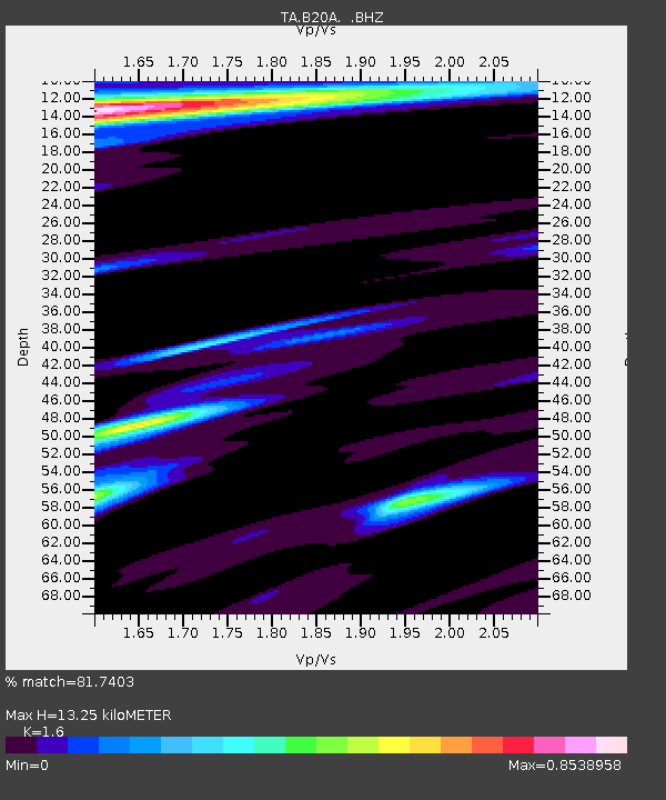
| Estimated Moho Depth: |
13.25 km |
| Estimated Crust Vp/Vs: |
1.60 |
| Assumed Crust Vp: |
6.438 km/s |
| Estimated Crust Vs: |
4.023 km/s |
| Estimated Crust Poisson's Ratio: |
0.18 |
|
| Radial Match: |
81.7403 % |
| Radial Bump: |
400 |
| Transverse Match: |
57.948467 % |
| Transverse Bump: |
400 |
| SOD ConfigId: |
2622 |
| Insert Time: |
2010-03-06 11:39:44.652 +0000 |
| GWidth: |
2.5 |
| Max Bumps: |
400 |
| Tol: |
0.001 |
|

Signal To Noise
| Channel | StoN | STA | LTA |
| TA:B20A: :BHZ:20090817T00:18:37.80002Z | 4.7631993 | 4.403564E-7 | 9.244971E-8 |
| TA:B20A: :BHN:20090817T00:18:37.80002Z | 1.362955 | 1.2846708E-7 | 9.425629E-8 |
| TA:B20A: :BHE:20090817T00:18:37.80002Z | 2.0022402 | 2.2892233E-7 | 1.14333105E-7 |
| Arrivals |
| Ps | 1.3 SECOND |
| PpPs | 5.2 SECOND |
| PsPs/PpSs | 6.5 SECOND |


