You are here: Home > Network List > TA - USArray Transportable Network (new EarthScope stations) Stations List
> Station B20A Solberg Farm, Malta, MT, USA > Earthquake Result Viewer
B20A Solberg Farm, Malta, MT, USA - Earthquake Result Viewer

| Earthquake location: |
Samoa Islands Region |
| Earthquake latitude/longitude: |
-15.5/-172.1 |
| Earthquake time(UTC): |
2009/09/29 (272) 17:48:10 GMT |
| Earthquake Depth: |
18 km |
| Earthquake Magnitude: |
7.1 MB, 8.1 MS, 8.1 MW, 8.0 MW |
| Earthquake Catalog/Contributor: |
WHDF/NEIC |
|
| Network: |
TA USArray Transportable Network (new EarthScope stations) |
| Station: |
B20A Solberg Farm, Malta, MT, USA |
| Lat/Lon: |
48.44 N/108.02 W |
| Elevation: |
827 m |
|
| Distance: |
85.3 deg |
| Az: |
36.938 deg |
| Baz: |
240.469 deg |
| Ray Param: |
0.04488134 |
| Estimated Moho Depth: |
42.25 km |
| Estimated Crust Vp/Vs: |
2.10 |
| Assumed Crust Vp: |
6.438 km/s |
| Estimated Crust Vs: |
3.073 km/s |
| Estimated Crust Poisson's Ratio: |
0.35 |
|
| Radial Match: |
98.74833 % |
| Radial Bump: |
386 |
| Transverse Match: |
93.603264 % |
| Transverse Bump: |
400 |
| SOD ConfigId: |
2622 |
| Insert Time: |
2010-03-06 11:39:48.002 +0000 |
| GWidth: |
2.5 |
| Max Bumps: |
400 |
| Tol: |
0.001 |
|
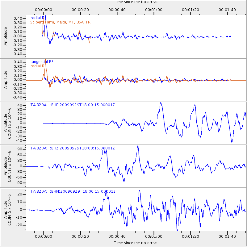
Signal To Noise
| Channel | StoN | STA | LTA |
| TA:B20A: :BHZ:20090929T18:00:15.00001Z | 18.57359 | 3.6224585E-6 | 1.9503275E-7 |
| TA:B20A: :BHN:20090929T18:00:15.00001Z | 1.5801853 | 4.0447134E-7 | 2.559645E-7 |
| TA:B20A: :BHE:20090929T18:00:15.00001Z | 3.8998997 | 1.1346541E-6 | 2.9094446E-7 |
| Arrivals |
| Ps | 7.3 SECOND |
| PpPs | 20 SECOND |
| PsPs/PpSs | 27 SECOND |


