You are here: Home > Network List > TA - USArray Transportable Network (new EarthScope stations) Stations List
> Station A21K Barrow, AK, USA > Earthquake Result Viewer
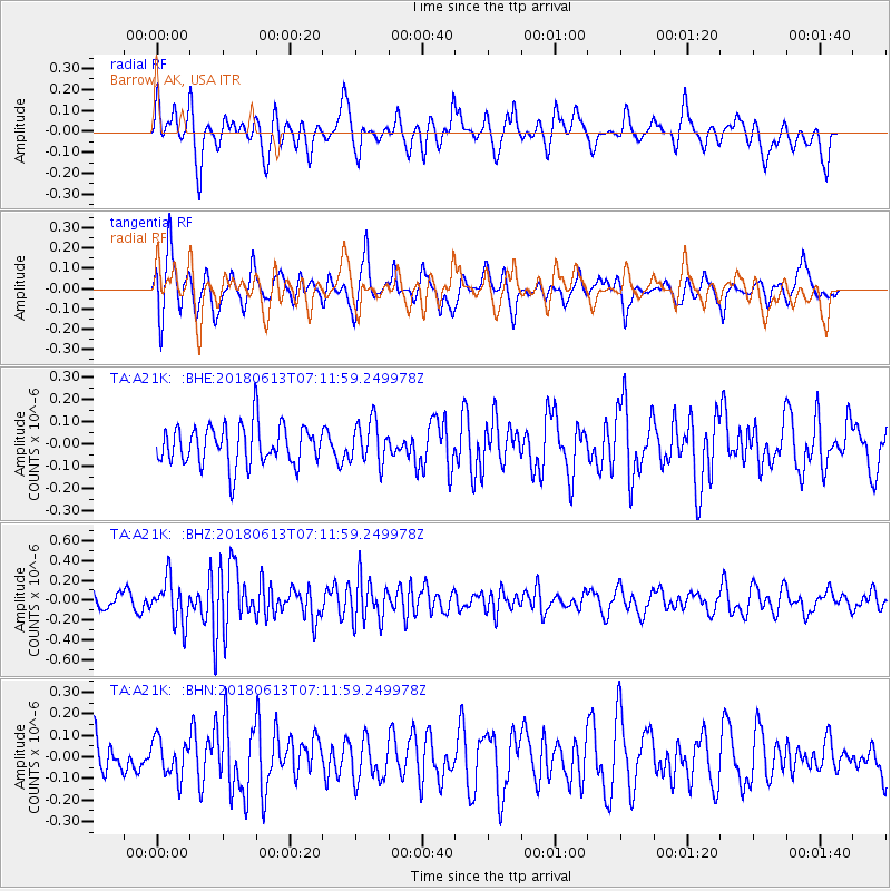
A21K Barrow, AK, USA - Earthquake Result Viewer
*The percent match for this event was below the threshold and hence no stack was calculated.
| Earthquake location: |
Southern Sumatra, Indonesia |
| Earthquake latitude/longitude: |
-1.9/98.7 |
| Earthquake time(UTC): |
2018/06/13 (164) 06:59:01 GMT |
| Earthquake Depth: |
10 km |
| Earthquake Magnitude: |
5.4 Mww |
| Earthquake Catalog/Contributor: |
NEIC PDE/us |
|
| Network: |
TA USArray Transportable Network (new EarthScope stations) |
| Station: |
A21K Barrow, AK, USA |
| Lat/Lon: |
71.32 N/156.62 W |
| Elevation: |
577 m |
|
| Distance: |
96.5 deg |
| Az: |
18.277 deg |
| Baz: |
283.374 deg |
| Ray Param: |
$rayparam |
*The percent match for this event was below the threshold and hence was not used in the summary stack. |
|
| Radial Match: |
62.26219 % |
| Radial Bump: |
359 |
| Transverse Match: |
54.876617 % |
| Transverse Bump: |
350 |
| SOD ConfigId: |
13570011 |
| Insert Time: |
2019-04-30 09:05:08.831 +0000 |
| GWidth: |
2.5 |
| Max Bumps: |
400 |
| Tol: |
0.001 |
|
Signal To Noise
| Channel | StoN | STA | LTA |
| TA:A21K: :BHZ:20180613T07:11:59.249978Z | 3.2292762 | 2.1929802E-7 | 6.790934E-8 |
| TA:A21K: :BHN:20180613T07:11:59.249978Z | 0.8160861 | 8.60915E-8 | 1.0549315E-7 |
| TA:A21K: :BHE:20180613T07:11:59.249978Z | 1.059931 | 9.595761E-8 | 9.053194E-8 |
| Arrivals |
| Ps | |
| PpPs | |
| PsPs/PpSs | |


