You are here: Home > Network List > TA - USArray Transportable Network (new EarthScope stations) Stations List
> Station I17K Unalakleet, AK, USA > Earthquake Result Viewer
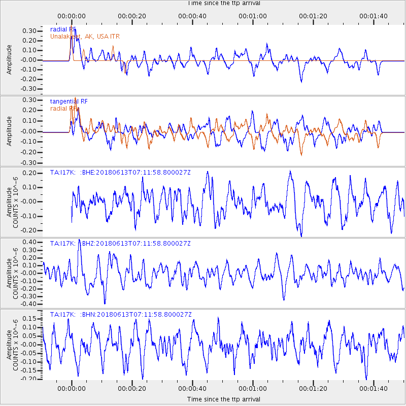
I17K Unalakleet, AK, USA - Earthquake Result Viewer
*The percent match for this event was below the threshold and hence no stack was calculated.
| Earthquake location: |
Southern Sumatra, Indonesia |
| Earthquake latitude/longitude: |
-1.9/98.7 |
| Earthquake time(UTC): |
2018/06/13 (164) 06:59:01 GMT |
| Earthquake Depth: |
10 km |
| Earthquake Magnitude: |
5.4 Mww |
| Earthquake Catalog/Contributor: |
NEIC PDE/us |
|
| Network: |
TA USArray Transportable Network (new EarthScope stations) |
| Station: |
I17K Unalakleet, AK, USA |
| Lat/Lon: |
63.89 N/160.70 W |
| Elevation: |
105 m |
|
| Distance: |
96.4 deg |
| Az: |
25.954 deg |
| Baz: |
278.735 deg |
| Ray Param: |
$rayparam |
*The percent match for this event was below the threshold and hence was not used in the summary stack. |
|
| Radial Match: |
54.98403 % |
| Radial Bump: |
400 |
| Transverse Match: |
64.088905 % |
| Transverse Bump: |
400 |
| SOD ConfigId: |
13570011 |
| Insert Time: |
2019-04-30 09:05:22.666 +0000 |
| GWidth: |
2.5 |
| Max Bumps: |
400 |
| Tol: |
0.001 |
|
Signal To Noise
| Channel | StoN | STA | LTA |
| TA:I17K: :BHZ:20180613T07:11:58.800027Z | 2.7177873 | 1.8967226E-7 | 6.978922E-8 |
| TA:I17K: :BHN:20180613T07:11:58.800027Z | 1.0726926 | 7.898263E-8 | 7.3630254E-8 |
| TA:I17K: :BHE:20180613T07:11:58.800027Z | 1.0614551 | 6.920974E-8 | 6.52027E-8 |
| Arrivals |
| Ps | |
| PpPs | |
| PsPs/PpSs | |


