You are here: Home > Network List > TA - USArray Transportable Network (new EarthScope stations) Stations List
> Station L15K Ungalak Mountain, AK, USA > Earthquake Result Viewer
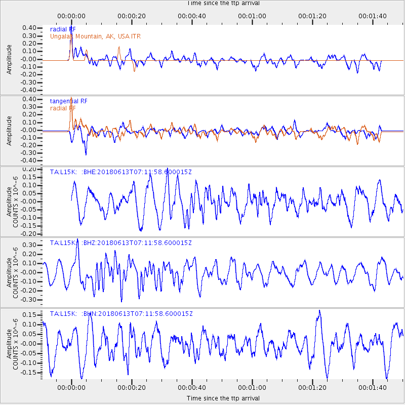
L15K Ungalak Mountain, AK, USA - Earthquake Result Viewer
*The percent match for this event was below the threshold and hence no stack was calculated.
| Earthquake location: |
Southern Sumatra, Indonesia |
| Earthquake latitude/longitude: |
-1.9/98.7 |
| Earthquake time(UTC): |
2018/06/13 (164) 06:59:01 GMT |
| Earthquake Depth: |
10 km |
| Earthquake Magnitude: |
5.4 Mww |
| Earthquake Catalog/Contributor: |
NEIC PDE/us |
|
| Network: |
TA USArray Transportable Network (new EarthScope stations) |
| Station: |
L15K Ungalak Mountain, AK, USA |
| Lat/Lon: |
61.68 N/161.49 W |
| Elevation: |
219 m |
|
| Distance: |
96.4 deg |
| Az: |
28.214 deg |
| Baz: |
277.781 deg |
| Ray Param: |
$rayparam |
*The percent match for this event was below the threshold and hence was not used in the summary stack. |
|
| Radial Match: |
61.531548 % |
| Radial Bump: |
400 |
| Transverse Match: |
53.734306 % |
| Transverse Bump: |
400 |
| SOD ConfigId: |
13570011 |
| Insert Time: |
2019-04-30 09:05:25.707 +0000 |
| GWidth: |
2.5 |
| Max Bumps: |
400 |
| Tol: |
0.001 |
|
Signal To Noise
| Channel | StoN | STA | LTA |
| TA:L15K: :BHZ:20180613T07:11:58.600015Z | 2.3336666 | 1.6153835E-7 | 6.922084E-8 |
| TA:L15K: :BHN:20180613T07:11:58.600015Z | 1.3276198 | 9.226185E-8 | 6.9494185E-8 |
| TA:L15K: :BHE:20180613T07:11:58.600015Z | 1.4748095 | 1.0782298E-7 | 7.310977E-8 |
| Arrivals |
| Ps | |
| PpPs | |
| PsPs/PpSs | |


