You are here: Home > Network List > TA - USArray Transportable Network (new EarthScope stations) Stations List
> Station B20A Solberg Farm, Malta, MT, USA > Earthquake Result Viewer
B20A Solberg Farm, Malta, MT, USA - Earthquake Result Viewer

| Earthquake location: |
Kuril Islands |
| Earthquake latitude/longitude: |
46.0/151.4 |
| Earthquake time(UTC): |
2009/04/18 (108) 19:17:58 GMT |
| Earthquake Depth: |
35 km |
| Earthquake Magnitude: |
6.3 MB, 6.3 MS, 6.6 MW, 6.4 MW |
| Earthquake Catalog/Contributor: |
WHDF/NEIC |
|
| Network: |
TA USArray Transportable Network (new EarthScope stations) |
| Station: |
B20A Solberg Farm, Malta, MT, USA |
| Lat/Lon: |
48.44 N/108.02 W |
| Elevation: |
827 m |
|
| Distance: |
63.3 deg |
| Az: |
47.146 deg |
| Baz: |
309.898 deg |
| Ray Param: |
0.059638508 |
| Estimated Moho Depth: |
17.5 km |
| Estimated Crust Vp/Vs: |
1.60 |
| Assumed Crust Vp: |
6.438 km/s |
| Estimated Crust Vs: |
4.023 km/s |
| Estimated Crust Poisson's Ratio: |
0.18 |
|
| Radial Match: |
92.232185 % |
| Radial Bump: |
391 |
| Transverse Match: |
81.5313 % |
| Transverse Bump: |
400 |
| SOD ConfigId: |
2658 |
| Insert Time: |
2010-03-06 11:39:59.367 +0000 |
| GWidth: |
2.5 |
| Max Bumps: |
400 |
| Tol: |
0.001 |
|
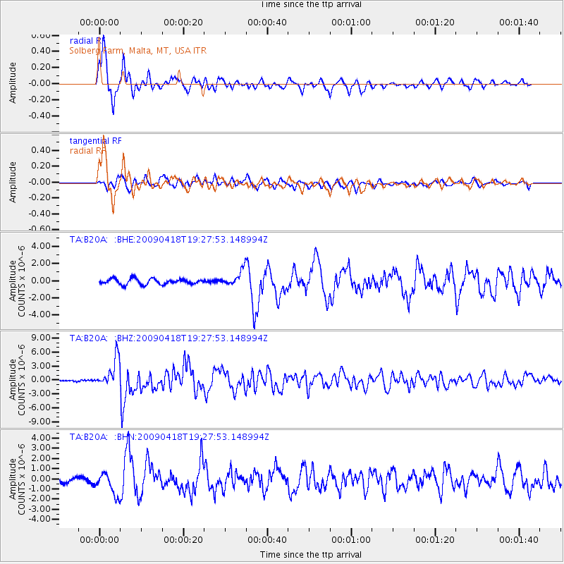
Signal To Noise
| Channel | StoN | STA | LTA |
| TA:B20A: :BHZ:20090418T19:27:53.148994Z | 20.889505 | 3.2301239E-6 | 1.5462903E-7 |
| TA:B20A: :BHN:20090418T19:27:53.148994Z | 3.7664115 | 1.1044074E-6 | 2.9322536E-7 |
| TA:B20A: :BHE:20090418T19:27:53.148994Z | 2.9024312 | 9.422017E-7 | 3.2462498E-7 |
| Arrivals |
| Ps | 1.7 SECOND |
| PpPs | 6.7 SECOND |
| PsPs/PpSs | 8.4 SECOND |


