You are here: Home > Network List > BK - Berkeley Digital Seismograph Network Stations List
> Station HUMO Hull Mountain, OR > Earthquake Result Viewer
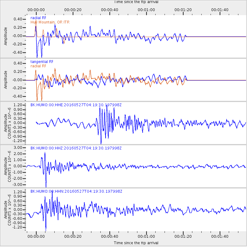
HUMO Hull Mountain, OR - Earthquake Result Viewer
*The percent match for this event was below the threshold and hence no stack was calculated.
| Earthquake location: |
Fiji Islands Region |
| Earthquake latitude/longitude: |
-20.8/-178.7 |
| Earthquake time(UTC): |
2016/05/27 (148) 04:08:44 GMT |
| Earthquake Depth: |
572 km |
| Earthquake Magnitude: |
6.4 MO |
| Earthquake Catalog/Contributor: |
NEIC PDE/NEIC ALERT |
|
| Network: |
BK Berkeley Digital Seismograph Network |
| Station: |
HUMO Hull Mountain, OR |
| Lat/Lon: |
42.61 N/122.96 W |
| Elevation: |
555 m |
|
| Distance: |
81.3 deg |
| Az: |
38.1 deg |
| Baz: |
231.428 deg |
| Ray Param: |
$rayparam |
*The percent match for this event was below the threshold and hence was not used in the summary stack. |
|
| Radial Match: |
58.606316 % |
| Radial Bump: |
400 |
| Transverse Match: |
61.59007 % |
| Transverse Bump: |
400 |
| SOD ConfigId: |
1475611 |
| Insert Time: |
2016-06-10 04:09:49.775 +0000 |
| GWidth: |
2.5 |
| Max Bumps: |
400 |
| Tol: |
0.001 |
|
Signal To Noise
| Channel | StoN | STA | LTA |
| BK:HUMO:00:HHZ:20160527T04:19:30.197998Z | 8.045685 | 7.75732E-7 | 9.641592E-8 |
| BK:HUMO:00:HHN:20160527T04:19:30.197998Z | 1.7372606 | 3.135561E-7 | 1.804888E-7 |
| BK:HUMO:00:HHE:20160527T04:19:30.197998Z | 2.5459347 | 3.6144695E-7 | 1.4197023E-7 |
| Arrivals |
| Ps | |
| PpPs | |
| PsPs/PpSs | |


