You are here: Home > Network List > TA - USArray Transportable Network (new EarthScope stations) Stations List
> Station B20A Solberg Farm, Malta, MT, USA > Earthquake Result Viewer
B20A Solberg Farm, Malta, MT, USA - Earthquake Result Viewer
| Earthquake location: |
Baffin Bay |
| Earthquake latitude/longitude: |
75.4/-72.5 |
| Earthquake time(UTC): |
2009/07/07 (188) 19:11:46 GMT |
| Earthquake Depth: |
19 km |
| Earthquake Magnitude: |
5.9 MB, 5.7 MS, 6.1 MW, 6.0 MW |
| Earthquake Catalog/Contributor: |
WHDF/NEIC |
|
| Network: |
TA USArray Transportable Network (new EarthScope stations) |
| Station: |
B20A Solberg Farm, Malta, MT, USA |
| Lat/Lon: |
48.44 N/108.02 W |
| Elevation: |
827 m |
|
| Distance: |
30.8 deg |
| Az: |
229.231 deg |
| Baz: |
16.824 deg |
| Ray Param: |
0.07923646 |
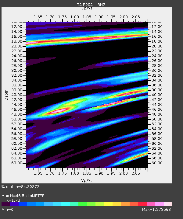
| Estimated Moho Depth: |
46.5 km |
| Estimated Crust Vp/Vs: |
1.73 |
| Assumed Crust Vp: |
6.438 km/s |
| Estimated Crust Vs: |
3.721 km/s |
| Estimated Crust Poisson's Ratio: |
0.25 |
|
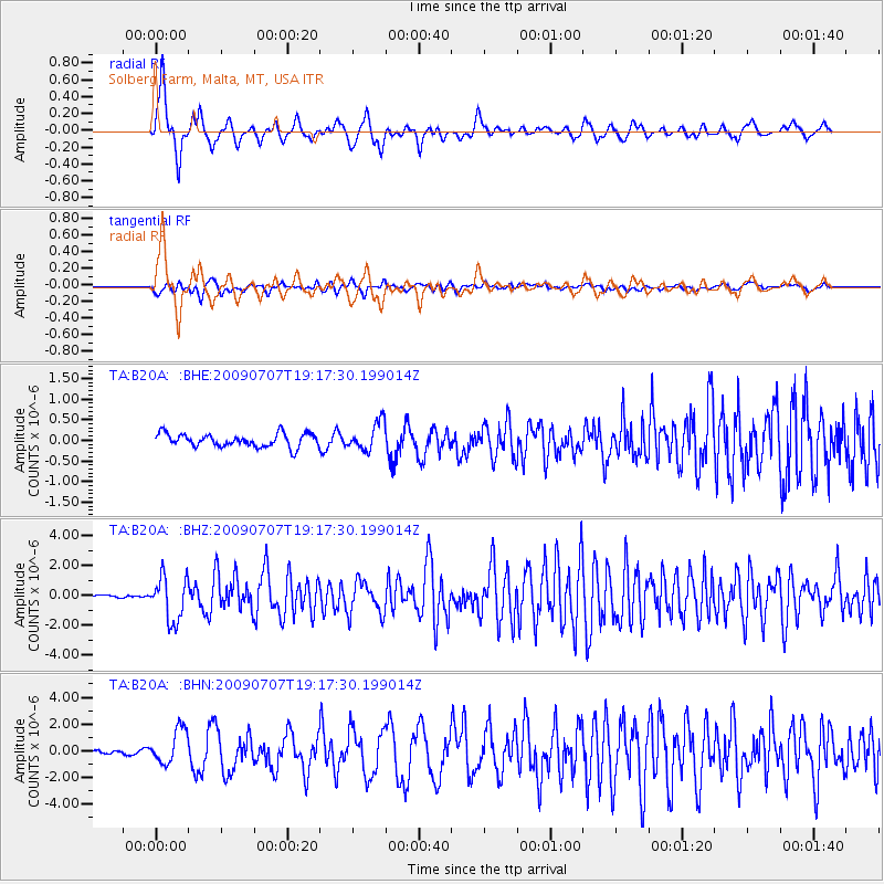
| Radial Match: |
84.30373 % |
| Radial Bump: |
400 |
| Transverse Match: |
68.30053 % |
| Transverse Bump: |
400 |
| SOD ConfigId: |
2648 |
| Insert Time: |
2010-03-06 11:40:04.363 +0000 |
| GWidth: |
2.5 |
| Max Bumps: |
400 |
| Tol: |
0.001 |
|
Signal To Noise
| Channel | StoN | STA | LTA |
| TA:B20A: :BHZ:20090707T19:17:30.199014Z | 14.000884 | 1.4759602E-6 | 1.0541907E-7 |
| TA:B20A: :BHN:20090707T19:17:30.199014Z | 7.566478 | 1.2980867E-6 | 1.7155759E-7 |
| TA:B20A: :BHE:20090707T19:17:30.199014Z | 2.1441927 | 3.4080762E-7 | 1.589445E-7 |
| Arrivals |
| Ps | 5.7 SECOND |
| PpPs | 18 SECOND |
| PsPs/PpSs | 24 SECOND |


