You are here: Home > Network List > TA - USArray Transportable Network (new EarthScope stations) Stations List
> Station J26L Joseph Creek, AK, USA > Earthquake Result Viewer
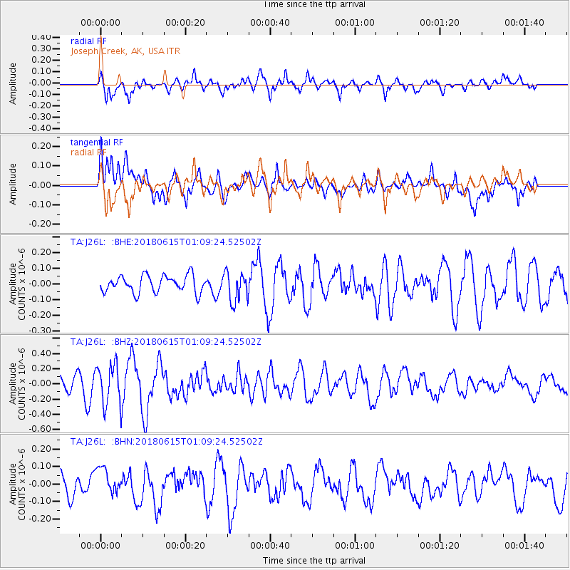
J26L Joseph Creek, AK, USA - Earthquake Result Viewer
*The percent match for this event was below the threshold and hence no stack was calculated.
| Earthquake location: |
Near North Coast Of Irian Jaya |
| Earthquake latitude/longitude: |
-2.0/138.8 |
| Earthquake time(UTC): |
2018/06/15 (166) 00:57:13 GMT |
| Earthquake Depth: |
10 km |
| Earthquake Magnitude: |
5.6 mb |
| Earthquake Catalog/Contributor: |
NEIC PDE/us |
|
| Network: |
TA USArray Transportable Network (new EarthScope stations) |
| Station: |
J26L Joseph Creek, AK, USA |
| Lat/Lon: |
64.50 N/143.56 W |
| Elevation: |
1144 m |
|
| Distance: |
86.5 deg |
| Az: |
25.067 deg |
| Baz: |
258.023 deg |
| Ray Param: |
$rayparam |
*The percent match for this event was below the threshold and hence was not used in the summary stack. |
|
| Radial Match: |
64.99386 % |
| Radial Bump: |
400 |
| Transverse Match: |
67.087654 % |
| Transverse Bump: |
400 |
| SOD ConfigId: |
13570011 |
| Insert Time: |
2019-04-30 09:24:06.245 +0000 |
| GWidth: |
2.5 |
| Max Bumps: |
400 |
| Tol: |
0.001 |
|
Signal To Noise
| Channel | StoN | STA | LTA |
| TA:J26L: :BHZ:20180615T01:09:24.52502Z | 2.1994193 | 2.7055626E-7 | 1.2301258E-7 |
| TA:J26L: :BHN:20180615T01:09:24.52502Z | 1.0395342 | 7.371836E-8 | 7.09148E-8 |
| TA:J26L: :BHE:20180615T01:09:24.52502Z | 1.7458966 | 9.466999E-8 | 5.422428E-8 |
| Arrivals |
| Ps | |
| PpPs | |
| PsPs/PpSs | |


