You are here: Home > Network List > TA - USArray Transportable Network (new EarthScope stations) Stations List
> Station G22K Bettles, AK, USA > Earthquake Result Viewer
G22K Bettles, AK, USA - Earthquake Result Viewer

| Earthquake location: |
Fiji Islands Region |
| Earthquake latitude/longitude: |
-16.2/-177.6 |
| Earthquake time(UTC): |
2018/06/16 (167) 03:23:32 GMT |
| Earthquake Depth: |
10 km |
| Earthquake Magnitude: |
5.5 mb |
| Earthquake Catalog/Contributor: |
NEIC PDE/us |
|
| Network: |
TA USArray Transportable Network (new EarthScope stations) |
| Station: |
G22K Bettles, AK, USA |
| Lat/Lon: |
66.92 N/151.51 W |
| Elevation: |
205 m |
|
| Distance: |
85.2 deg |
| Az: |
10.024 deg |
| Baz: |
205.095 deg |
| Ray Param: |
0.044968978 |
| Estimated Moho Depth: |
13.0 km |
| Estimated Crust Vp/Vs: |
1.60 |
| Assumed Crust Vp: |
6.577 km/s |
| Estimated Crust Vs: |
4.104 km/s |
| Estimated Crust Poisson's Ratio: |
0.18 |
|
| Radial Match: |
81.27756 % |
| Radial Bump: |
400 |
| Transverse Match: |
75.90127 % |
| Transverse Bump: |
400 |
| SOD ConfigId: |
13570011 |
| Insert Time: |
2019-04-30 09:30:17.186 +0000 |
| GWidth: |
2.5 |
| Max Bumps: |
400 |
| Tol: |
0.001 |
|
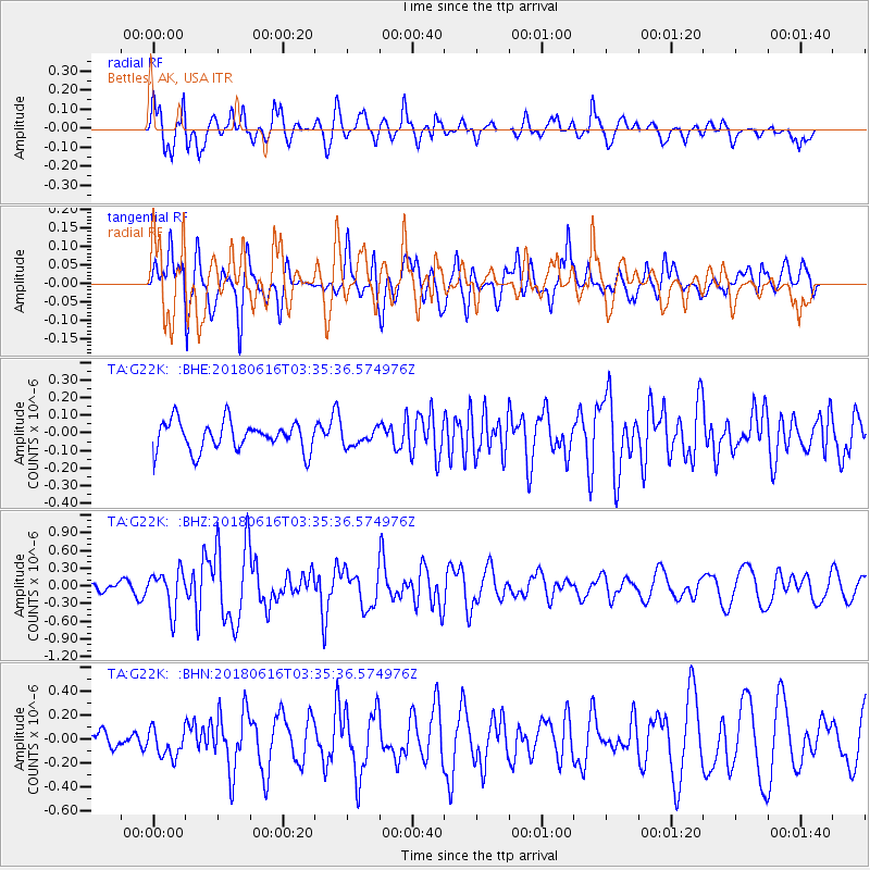
Signal To Noise
| Channel | StoN | STA | LTA |
| TA:G22K: :BHZ:20180616T03:35:36.574976Z | 5.256372 | 3.264689E-7 | 6.210917E-8 |
| TA:G22K: :BHN:20180616T03:35:36.574976Z | 1.3068651 | 1.16984076E-7 | 8.951504E-8 |
| TA:G22K: :BHE:20180616T03:35:36.574976Z | 0.59337085 | 4.778028E-8 | 8.052346E-8 |
| Arrivals |
| Ps | 1.2 SECOND |
| PpPs | 5.0 SECOND |
| PsPs/PpSs | 6.2 SECOND |


