You are here: Home > Network List > TA - USArray Transportable Network (new EarthScope stations) Stations List
> Station C19A Slack Wire Ranch, Winifred, MT, USA > Earthquake Result Viewer
C19A Slack Wire Ranch, Winifred, MT, USA - Earthquake Result Viewer
| Earthquake location: |
Near Coast Of Chiapas, Mexico |
| Earthquake latitude/longitude: |
14.4/-92.4 |
| Earthquake time(UTC): |
2008/10/16 (290) 19:41:25 GMT |
| Earthquake Depth: |
24 km |
| Earthquake Magnitude: |
6.1 MB, 6.6 MS, 6.7 MW, 6.6 MW |
| Earthquake Catalog/Contributor: |
WHDF/NEIC |
|
| Network: |
TA USArray Transportable Network (new EarthScope stations) |
| Station: |
C19A Slack Wire Ranch, Winifred, MT, USA |
| Lat/Lon: |
47.73 N/109.05 W |
| Elevation: |
966 m |
|
| Distance: |
36.0 deg |
| Az: |
340.743 deg |
| Baz: |
151.747 deg |
| Ray Param: |
0.07688829 |
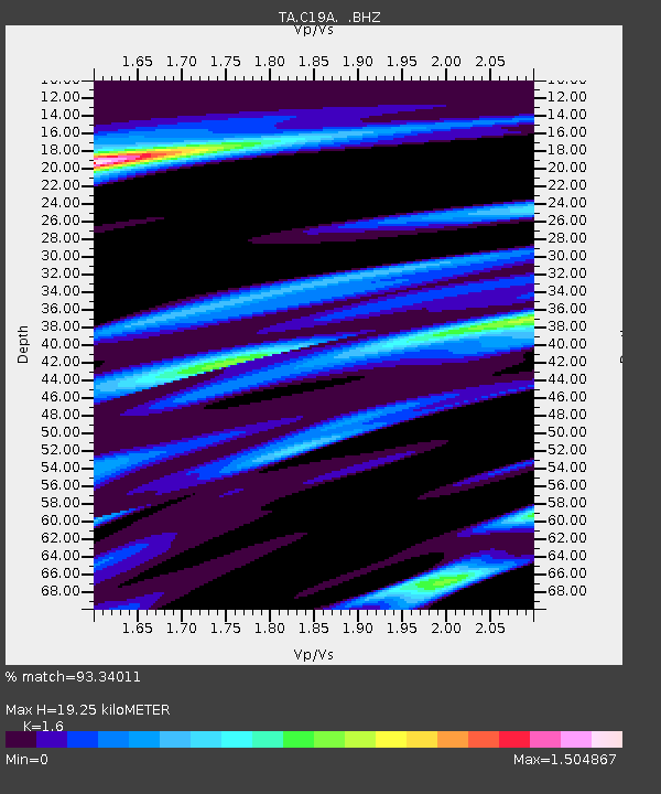
| Estimated Moho Depth: |
19.25 km |
| Estimated Crust Vp/Vs: |
1.60 |
| Assumed Crust Vp: |
6.518 km/s |
| Estimated Crust Vs: |
4.074 km/s |
| Estimated Crust Poisson's Ratio: |
0.18 |
|
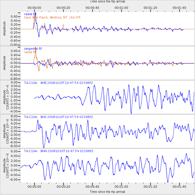
| Radial Match: |
93.34011 % |
| Radial Bump: |
293 |
| Transverse Match: |
78.73705 % |
| Transverse Bump: |
356 |
| SOD ConfigId: |
2556 |
| Insert Time: |
2010-03-06 11:42:16.720 +0000 |
| GWidth: |
2.5 |
| Max Bumps: |
400 |
| Tol: |
0.001 |
|
Signal To Noise
| Channel | StoN | STA | LTA |
| TA:C19A: :BHZ:20081016T19:47:54.023986Z | 16.738493 | 2.7385106E-6 | 1.6360555E-7 |
| TA:C19A: :BHN:20081016T19:47:54.023986Z | 6.3737555 | 1.553906E-6 | 2.4379756E-7 |
| TA:C19A: :BHE:20081016T19:47:54.023986Z | 3.5096357 | 1.0983938E-6 | 3.1296517E-7 |
| Arrivals |
| Ps | 1.9 SECOND |
| PpPs | 7.0 SECOND |
| PsPs/PpSs | 9.0 SECOND |


