You are here: Home > Network List > TA - USArray Transportable Network (new EarthScope stations) Stations List
> Station C19A Slack Wire Ranch, Winifred, MT, USA > Earthquake Result Viewer
C19A Slack Wire Ranch, Winifred, MT, USA - Earthquake Result Viewer
| Earthquake location: |
Vanuatu Islands |
| Earthquake latitude/longitude: |
-13.5/167.0 |
| Earthquake time(UTC): |
2008/09/08 (252) 18:52:06 GMT |
| Earthquake Depth: |
110 km |
| Earthquake Magnitude: |
6.4 MB, 6.9 MW, 6.9 MW |
| Earthquake Catalog/Contributor: |
WHDF/NEIC |
|
| Network: |
TA USArray Transportable Network (new EarthScope stations) |
| Station: |
C19A Slack Wire Ranch, Winifred, MT, USA |
| Lat/Lon: |
47.73 N/109.05 W |
| Elevation: |
966 m |
|
| Distance: |
95.9 deg |
| Az: |
42.444 deg |
| Baz: |
256.524 deg |
| Ray Param: |
0.040587533 |
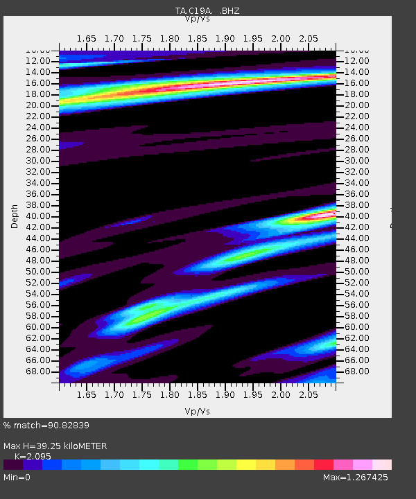
| Estimated Moho Depth: |
39.25 km |
| Estimated Crust Vp/Vs: |
2.10 |
| Assumed Crust Vp: |
6.518 km/s |
| Estimated Crust Vs: |
3.111 km/s |
| Estimated Crust Poisson's Ratio: |
0.35 |
|
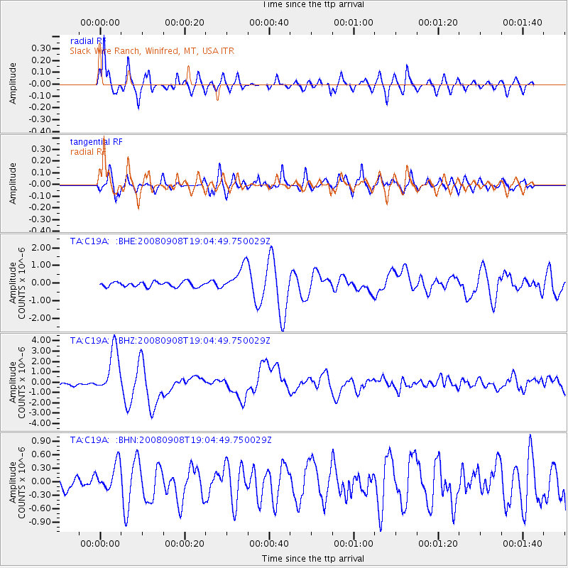
| Radial Match: |
90.82839 % |
| Radial Bump: |
375 |
| Transverse Match: |
74.91889 % |
| Transverse Bump: |
400 |
| SOD ConfigId: |
2560 |
| Insert Time: |
2010-03-06 11:42:17.556 +0000 |
| GWidth: |
2.5 |
| Max Bumps: |
400 |
| Tol: |
0.001 |
|
Signal To Noise
| Channel | StoN | STA | LTA |
| TA:C19A: :BHZ:20080908T19:04:49.750029Z | 20.928627 | 2.2726583E-6 | 1.08590896E-7 |
| TA:C19A: :BHN:20080908T19:04:49.750029Z | 1.1933188 | 3.203054E-7 | 2.6841562E-7 |
| TA:C19A: :BHE:20080908T19:04:49.750029Z | 5.5621057 | 7.678603E-7 | 1.3805209E-7 |
| Arrivals |
| Ps | 6.7 SECOND |
| PpPs | 18 SECOND |
| PsPs/PpSs | 25 SECOND |


