You are here: Home > Network List > AV - Alaska Volcano Observatory Stations List
> Station AMKA Regional Station, Amchitka Island, Alaska > Earthquake Result Viewer
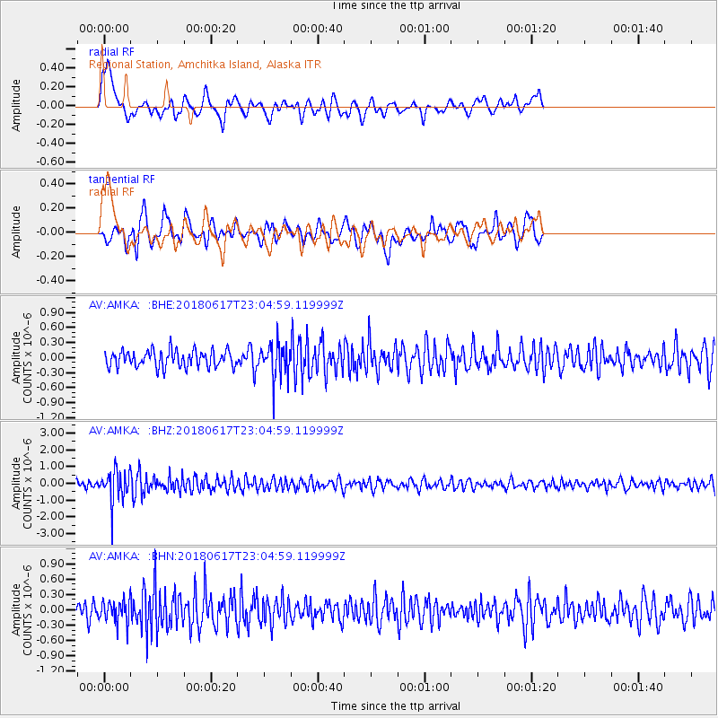
AMKA Regional Station, Amchitka Island, Alaska - Earthquake Result Viewer
*The percent match for this event was below the threshold and hence no stack was calculated.
| Earthquake location: |
Near S. Coast Of Western Honshu |
| Earthquake latitude/longitude: |
34.8/135.6 |
| Earthquake time(UTC): |
2018/06/17 (168) 22:58:35 GMT |
| Earthquake Depth: |
11 km |
| Earthquake Magnitude: |
5.5 Mww |
| Earthquake Catalog/Contributor: |
NEIC PDE/us |
|
| Network: |
AV Alaska Volcano Observatory |
| Station: |
AMKA Regional Station, Amchitka Island, Alaska |
| Lat/Lon: |
51.38 N/179.30 E |
| Elevation: |
116 m |
|
| Distance: |
35.3 deg |
| Az: |
48.476 deg |
| Baz: |
259.321 deg |
| Ray Param: |
$rayparam |
*The percent match for this event was below the threshold and hence was not used in the summary stack. |
|
| Radial Match: |
62.247894 % |
| Radial Bump: |
400 |
| Transverse Match: |
63.707035 % |
| Transverse Bump: |
400 |
| SOD ConfigId: |
13570011 |
| Insert Time: |
2019-04-30 09:34:28.182 +0000 |
| GWidth: |
2.5 |
| Max Bumps: |
400 |
| Tol: |
0.001 |
|
Signal To Noise
| Channel | StoN | STA | LTA |
| AV:AMKA: :BHZ:20180617T23:04:59.119999Z | 4.8892603 | 9.440871E-7 | 1.9309405E-7 |
| AV:AMKA: :BHN:20180617T23:04:59.119999Z | 1.1512847 | 2.2346578E-7 | 1.9410122E-7 |
| AV:AMKA: :BHE:20180617T23:04:59.119999Z | 2.2618465 | 3.6791644E-7 | 1.6266198E-7 |
| Arrivals |
| Ps | |
| PpPs | |
| PsPs/PpSs | |


