You are here: Home > Network List > CC - Cascade Chain Volcano Monitoring Stations List
> Station SWNB Southwest, Newberry, OR > Earthquake Result Viewer
SWNB Southwest, Newberry, OR - Earthquake Result Viewer
| Earthquake location: |
Near S. Coast Of Western Honshu |
| Earthquake latitude/longitude: |
34.8/135.6 |
| Earthquake time(UTC): |
2018/06/17 (168) 22:58:35 GMT |
| Earthquake Depth: |
11 km |
| Earthquake Magnitude: |
5.5 Mww |
| Earthquake Catalog/Contributor: |
NEIC PDE/us |
|
| Network: |
CC Cascade Chain Volcano Monitoring |
| Station: |
SWNB Southwest, Newberry, OR |
| Lat/Lon: |
43.67 N/121.36 W |
| Elevation: |
1569 m |
|
| Distance: |
75.1 deg |
| Az: |
47.005 deg |
| Baz: |
303.983 deg |
| Ray Param: |
0.05187233 |
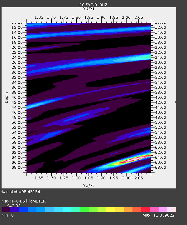
| Estimated Moho Depth: |
64.5 km |
| Estimated Crust Vp/Vs: |
2.03 |
| Assumed Crust Vp: |
6.597 km/s |
| Estimated Crust Vs: |
3.25 km/s |
| Estimated Crust Poisson's Ratio: |
0.34 |
|
| Radial Match: |
95.45154 % |
| Radial Bump: |
251 |
| Transverse Match: |
42.188305 % |
| Transverse Bump: |
296 |
| SOD ConfigId: |
13570011 |
| Insert Time: |
2019-04-30 09:35:11.870 +0000 |
| GWidth: |
2.5 |
| Max Bumps: |
400 |
| Tol: |
0.001 |
|

Signal To Noise
| Channel | StoN | STA | LTA |
| CC:SWNB: :BHZ:20180617T23:09:45.519993Z | 1.5649925 | 3.2697685E-6 | 2.089319E-6 |
| CC:SWNB: :BHN:20180617T23:09:45.519993Z | 0.9791912 | 1.753315E-5 | 1.7905746E-5 |
| CC:SWNB: :BHE:20180617T23:09:45.519993Z | 1.0828981 | 1.9694371E-5 | 1.8186725E-5 |
| Arrivals |
| Ps | 10 SECOND |
| PpPs | 29 SECOND |
| PsPs/PpSs | 39 SECOND |


