You are here: Home > Network List > CI - Caltech Regional Seismic Network Stations List
> Station MPM Manuel Prospect Mine, California, USA > Earthquake Result Viewer
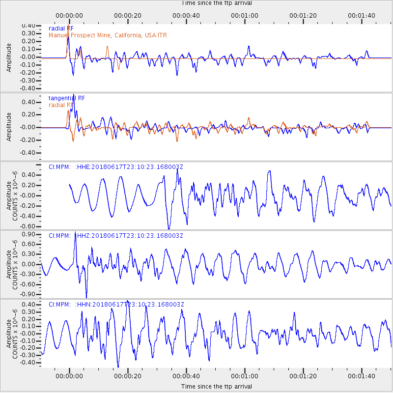
MPM Manuel Prospect Mine, California, USA - Earthquake Result Viewer
*The percent match for this event was below the threshold and hence no stack was calculated.
| Earthquake location: |
Near S. Coast Of Western Honshu |
| Earthquake latitude/longitude: |
34.8/135.6 |
| Earthquake time(UTC): |
2018/06/17 (168) 22:58:35 GMT |
| Earthquake Depth: |
11 km |
| Earthquake Magnitude: |
5.5 Mww |
| Earthquake Catalog/Contributor: |
NEIC PDE/us |
|
| Network: |
CI Caltech Regional Seismic Network |
| Station: |
MPM Manuel Prospect Mine, California, USA |
| Lat/Lon: |
36.06 N/117.49 W |
| Elevation: |
185 m |
|
| Distance: |
82.0 deg |
| Az: |
51.532 deg |
| Baz: |
307.358 deg |
| Ray Param: |
$rayparam |
*The percent match for this event was below the threshold and hence was not used in the summary stack. |
|
| Radial Match: |
49.314518 % |
| Radial Bump: |
381 |
| Transverse Match: |
79.681854 % |
| Transverse Bump: |
395 |
| SOD ConfigId: |
13570011 |
| Insert Time: |
2019-04-30 09:35:31.517 +0000 |
| GWidth: |
2.5 |
| Max Bumps: |
400 |
| Tol: |
0.001 |
|
Signal To Noise
| Channel | StoN | STA | LTA |
| CI:MPM: :HHZ:20180617T23:10:23.168003Z | 1.2035239 | 3.4058107E-7 | 2.8298655E-7 |
| CI:MPM: :HHN:20180617T23:10:23.168003Z | 1.0365001 | 1.5631306E-7 | 1.5080853E-7 |
| CI:MPM: :HHE:20180617T23:10:23.168003Z | 1.5959473 | 3.407159E-7 | 2.1348819E-7 |
| Arrivals |
| Ps | |
| PpPs | |
| PsPs/PpSs | |


